
Marine
MRV Scotia: Survey 1114S – Groundfish Survey
August 4, 2014 by Marine Scotland Communications No Comments | Category Fisheries, Marine Directorate Science, Research Vessel Surveys
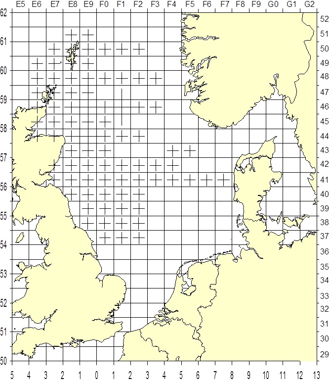
Proposed Survey Track: Scotia 1114S
Overview of survey
The MRV Scotia will sail on the morning of Thursday 31July. The first station is located not far from Aberdeen so once the safety drills have been completed, the Scotia will proceed to the first station where a shakedown haul will be completed in advance of the first real haul in order to check the net configuration and Scanmar units.
There are 84 programmed rectangles to be surveyed and these are highlighted on the attached chart. Depending on the progress of the other survey participants, six of these rectangles (51E9, 49E9, 47E9, 45F0, 44F0 and 44F1) may be dropped allowing three secondary stations to be sampled on the northern boundary of the survey area at 52E9, 52F0 and 52F1. Contact will be maintained with the other survey participants prior to and during the survey and a decision will be made regarding these additional stations once more information is available. One demersal haul of 30 minutes duration will be made in each of the highlighted statistical rectangles.
Trawling will be undertaken during the hours of daylight which will vary depending on the vessels latitude at any given time. The scanmar system will be used to monitor the headline height, wing spread and door spread for each haul. Bottom contact data from each trawl will also be collected using the NOAA bottom contact sensor which will be mounted in the centre of the ground-gear. In addition to the routine sampling, biological data will be collected for target species in line with the EU data regulation. All fish will be processed in accordance with Standing Instructions.
CTD casts will be taken at every trawl station (a CTD is an oceanography instrument that provide surface and bottom temperature and salinity information). Reverser bottles attached to the CTD wire will also be used to collect water samples that will be analysed back at the lab and will provide information on salinities, nitrates, silicates and phosphates. In addition the ships thermosalinograph will be run continuously throughout the survey and will provide sea surface temperature and salinity data.
Duration: 31 July – 22 August 2014
Fishing Gear: GOV Trawl (BT 137) with ground gear A & B
Objectives
- To complete an internationally coordinated demersal trawling survey in theNorth Seain ICES area IV
- To obtain temperature and salinity data from the surface and seabed at each trawling station using a SEABIRD 19+ CTD
- EDC (electronic data capture) and FSS database utilised for recording all biological survey data.
- Collect additional biological data in connection with the EU Data Collection Framework (DCF).

Leave a comment