
Marine
MRV Scotia: Survey 1116S Programme
July 27, 2016 by Marine Scotland Communications No Comments | Category Fisheries, Marine Directorate Science, Marine Directorate Surveys
Gear:
- GOV Trawl (BT 137) with ground gear A & B
Objectives:
- To complete an internationally coordinated demersal trawling survey in the North Sea in ICES area IV and continue an IBTS tow duration experiment.
- To obtain temperature and salinity data from the surface and seabed at each trawling station using a SEABIRD 19+ CTD.
- Collect additional biological data in connection with the EU Data Collection Framework (DCF).
Procedures
General
The Scotia will set sail on the morning of Friday 5 August from Aberdeen. Scotia will then proceed to the first station northeast of Peterhead at the Buchan Deeps.
Trawling
There are 82 programmed rectangles to be surveyed and these are presented on the chart below (Figure 1).
Following on from the successful tow duration experiment conducted in 2015, it has been decided to continue the experiment for 2016. Within the entire international survey area where two trawls are currently undertaken, one will be of 30 minutes duration whilst the other would be of 15 minutes duration. This will allow a dual set of abundance indices to be calculated for the assessed species and allow further analysis to determine if the reduction in bottom time has any significant effect on catchability for certain assessed species. As a parameter of diversity, species richness will also be compared. The reduction of stations as well as the tow duration experiment should allow additional stations (see Figure 2.) to be sampled in the area to the south and west of Shetland.
In addition, Scotland is the tertiary country in eight rectangles and will only be required to undertake a tow if the primary and secondary country fail to do so (see Figure 1). Contact will be maintained with the other survey participants prior to and during the survey and a decision will be made regarding these stations and additional stations once the survey is underway. Trawling will be undertaken during the hours of daylight which will vary depending on the vessels latitude at any given time and the survey trawl will be used during the survey using short sweeps. The SCANMAR system will be used to monitor the headline height, wing spread and door spread for each haul and bottom contact data from each trawl will also be collected using the NOAA bottom contact sensor which will be mounted in the centre of the ground-gear.
Hydrography
CTD casts (conductivity/temperature/depth) will be taken at every trawl station which provide surface and bottom temperature and salinity information. Reverser bottles affixed to the CTD wire will also be used to collect water samples that will be analysed back at the lab and will provide information on salinities, nitrates, silicates and phosphates.
Further Information
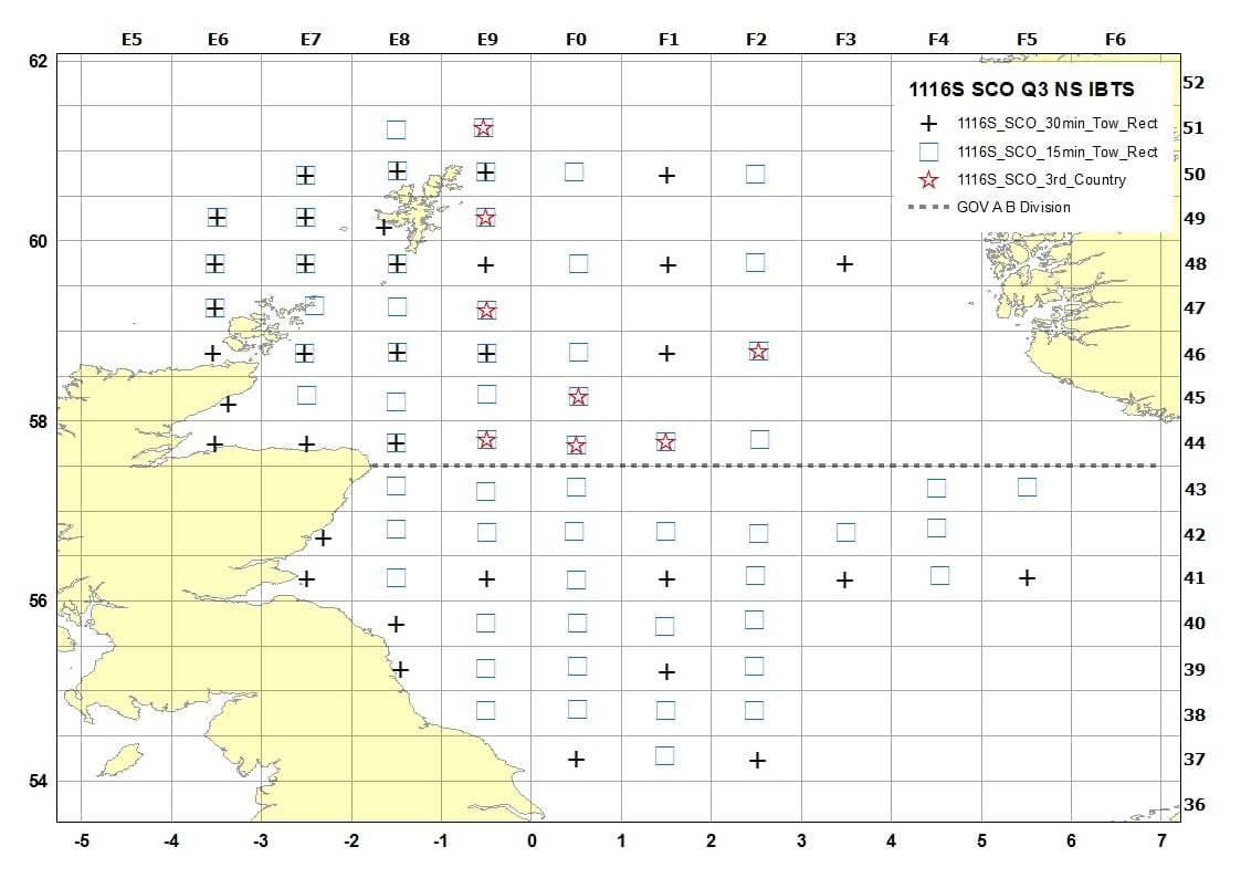
Figure 1 – 1116S Area for Scotland
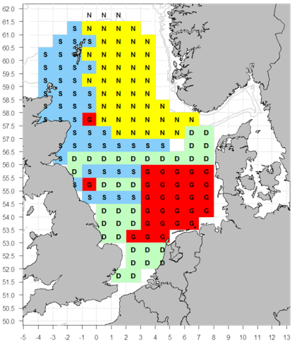
Figure 2: Proposed areas Denmark, Scotland, Germany, and Norway should focus their additional tows. Scotland areas in blue and with the letter S

Leave a comment