
Marine
How the HoTRiverS Project is helping us to understand and protect Scotland’s rivers
April 17, 2018 by Marine Scotland Communications No Comments | Category Collaborations, Freshwater Fisheries, Marine Directorate Science
One of the ways in which climate change is likely to impact Scotland’s rivers is through an increase in water temperature, particularly during summer months. Stream temperature is of great importance to the growth and survival of a range of iconic fish species like Atlantic salmon and Brown trout, which are relatively intolerant of high temperature. Hence, there are concerns that elevated stream temperature could alter the thermal suitability of Scotland’s rivers to a range of native freshwater species. As a result, researchers at Marine Scotland Science (MSS) and the University of Birmingham (UoB) have collaborated on a number of projects to better understand stream temperature patterns in Scotland’s rivers and identify strategies for reducing the impacts of climate change on stream temperature. One of these collaborations, the EU-funded HoTRiverS project (Heterogeneity of Temperature in Rivers and Streams), is demonstrating how cutting-edge technology can inform river management and policy in the fight against climate change.
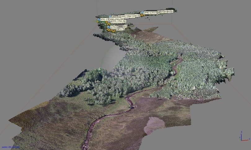
River managers across the UK are planting trees to shade rivers during the warmest parts of the day. However, if we want to improve our understanding of the role of trees in reducing stream temperature, we need to be better able to characterise both tree cover and the effects of river bankside shading. This information can be difficult or costly to obtain, especially in remote locations. To address this key research problem, the HoTRiverS project team developed a novel based methodology to simulate the impacts of bankside tree shading on stream temperature. During summer 2017, they used a drone (a small unmanned quadcopter equipped with a high-resolution camera) to obtain high resolution aerial photography of Girnock Burn, a tributary of the Aberdeenshire River Dee where Marine Scotland has monitored salmon populations for more than 50 years.). Using a technique called ‘structure-from-motion photogrammetry’, which enables the extraction of 3D data from 2D photos (in much the same way as stereo vision allows humans to perceive depth), they were able to generate a highly accurate 3D map of tree heights in the lower Girnock Burn (see picture at the top of this article).
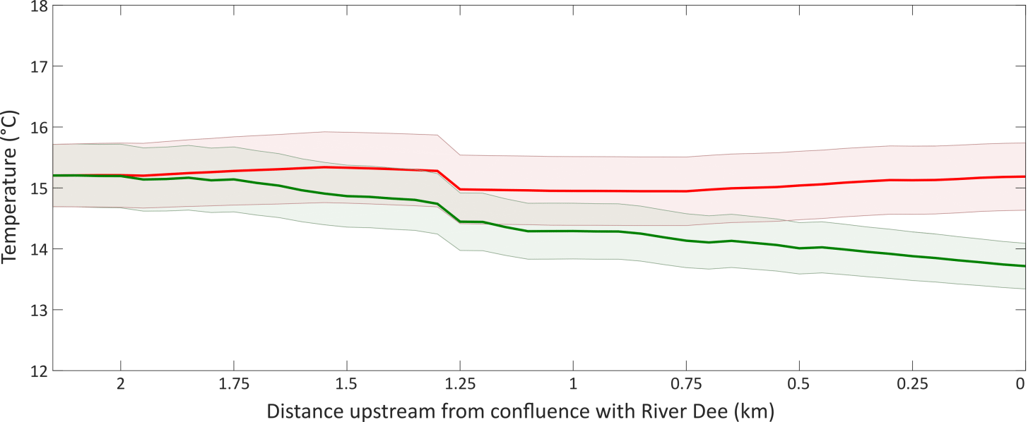
By inputting the resulting tree height data into a computer model that simulates the impacts of tree shading on stream temperature, the new methodology clearly highlights the extent to which tree shading reduces stream temperature in the lower Girnock Burn (see graph above). This new low-cost, high-accuracy technique has the potential to improve our understanding about how and where tree shading produces optimal stream temperature reductions. By applying the drone-based methodology to other locations in Scotland and across the UK, it is hoped that this research will furnish river scientists and managers with the information necessary to understand the effects of woodland in different geographical locations. Based on this information, new tools can be developed to target planting to locations where it will have the greatest benefits in reducing the effects of climate change.
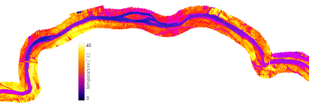
Furthermore, the HoTRiverS project is highlighting other ways in which drone technology can help scientists to better understand stream temperature patterns. Previous research has shown how airborne thermal infrared (TIR) river surveys can be used to identify important cool-water habitats used by salmon and trout during summer high temperature. However, TIR survey flights using conventional aircraft are very costly meaning that the location of these critical habitats often remains unknown. In order to try and resolve this issue, the HoTRiverS research team used a drone equipped with a miniaturised thermal infrared imaging camera to map surface water temperature patterns in Baddoch Burn, another salmon monitoring tributary in the Aberdeenshire Dee catchment, as illustrated above.
Although the analysis of these data is ongoing, early indications are that the drone-based thermal imaging data will be useful for detecting small-scale variations in surface water temperature that are of key importance to fish and other species.
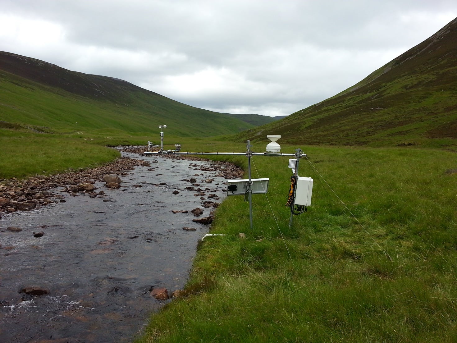
This detailed spatial data on river temperature has been supplemented with observations obtained from in-situ temperature dataloggers and automated weather stations (pictured above) to characterise microclimate and heat exchange processes. By coupling these datasets, it will be possible to develop a high resolution computer model capable of characterising the physical processes (ie. solar radiation, evaporation, groundwater inputs) that drive observed stream temperature patterns in the burn.
In the future, this model will help us to understand and predict how future climate and land-use changes might impact stream temperature in Baddoch Burn. This collaboration between MSS and UoB demonstrates how advances in geospatial technology and computer modelling are helping to better understand and protect Scotland’s freshwater environments. Through the results of these cutting-edge research projects, it is hoped that we will arrive at a better understanding of the interactions between the landscape features, climate change and river temperature with a view to preserving Scotland’s valuable rivers and fish populations for future generations.
Further information:
- The HoTRiverS project website
- The Scotland River Temperature Monitoring Network (SRTMN)
- Where should we plant trees to protect rivers from high water temperatures
Recent/related publications:
Dugdale, S.J., Malcolm, I.A., Kantola, K., & Hannah, D.M. (2018). Stream temperature under contrasting riparian forest cover: Understanding thermal dynamics and heat exchange processes. Science of The Total Environment, 610–611, 1375-1389
Jackson, F.L., Fryer, R.J., Hannah, D.M., Millar, C.P., & Malcolm, I.A. (2018). A spatio-temporal statistical model of maximum daily river temperatures to inform the management of Scotland’s Atlantic salmon rivers under climate change. Science of The Total Environment, 612, 1543-1558
Dugdale, S.J., Hannah, D.M., & Malcolm, I.A. (2017). River temperature modelling: A review of process-based approaches and future directions. Earth-Science Reviews, 175, 97-113
Jackson, F.L., Hannah, D.M., Fryer, R.J., Millar, C.P., & Malcolm, I.A. (2017). Development of spatial regression models for predicting summer river temperatures from landscape characteristics: Implications for land and fisheries management. Hydrological Processes, 31, 1225-1238
Garner, G., Malcolm, I.A., Sadler, J.P., & Hannah, D.M. (2014). What causes cooling water temperature gradients in a forested stream reach? Hydrol. Earth Syst. Sci., 18, 5361-5376
Garner, G., Malcolm, I.A., Sadler, J.P., & Hannah, D.M. (2017). The role of riparian vegetation density, channel orientation and water velocity in determining river temperature dynamics. Journal of Hydrology, 553
Tags: Freshwater, research, Trees

Leave a comment