
Marine
ECOMASS Moorings on East Coast
November 16, 2019 by Marine Directorate Communications No Comments | Category Collaborations, Fisheries, Marine Directorate general, Marine Directorate Science, Marine Directorate Surveys, Marine Environment
MRV Alba na Mara Programme
Survey: 2019A
Duration: 15-26 November 2019
Gear: Surface and subsurface PAM moorings
Objectives:
To retrieve 24 subsurface moorings comprising acoustic release systems and the acoustic recording devices attached to them (24 C-POD and 8 Loggerhead/SM2M) as part of three marine mammal monitoring programmes (ECOMMAS, JOMOPANS & SEAGREEN).
To deploy 11 subsurface moorings comprising acoustic release systems and the acoustic recording devices attached to them (11 CPOD and 11 Loggerhead/SM2M) as part of four marine mammal monitoring programmes (ECOMMAS, JOMOPANS, SEAGREEN & NNG). See Table 1-4 and Figure 1-3.
Procedure:
Loading of all equipment will be carried out on 12 November when the previous survey (1919A) returns to Fraserburgh. Weather permitting, Alba na Mara will sail from Fraserburgh on the morning of 15 November and make for the first mooring position. The ultimate order in which the moorings are retrieved/deployed will be decided by the skipper in conjunction with the SIC, and dictated by the weather forecast.
It may be necessary for Alba na Mara to make a partial unloading of retrieved moorings and equipment to ensure enough available space on the vessel. If this is the case the vessel will visit the most suitable port depending on her location at the time.
Alba na Mara will dock in Leith on 26 November to unload and allow the scientific staff to disembark and return to Aberdeen.
Table 1: Geographic position of all 19 JOMOPANS & ECOMMAS moorings to be recovered.
| Location | Latitude | Longitude | Sound recorder? |
| JOMOPANS 1 | 58.57487 | -2.119471 | Y |
| Fraserburgh 5 | 57.711263 | -2.130103 | |
| Fraserburgh 10 | 57.770775 | -2.141328 | |
| Fraserburgh 15 | 57.849141 | -2.089825 | |
| Cruden Bay 5 | 57.380185 | -1.828393 | Y |
| Cruden Bay 10 | 57.380146 | -1.738071 | |
| Cruden Bay 15 | 57.376868 | -1.61793 | |
| Stonehaven 15 | 56.98059 | -2.021736 | |
| Stonehaven 10 | 56.959511 | -2.113503 | |
| Stonehaven 5 | 56.947156 | -2.177253 | Y |
| Arbroath 5 | 56.554018 | -2.483356 | |
| Arbroath 10 | 56.499815 | -2.37981 | Y |
| Arbroath 15 | 56.459636 | -2.29853 | |
| St Andrews 15 | 56.29004 | -2.433171 | |
| St Andrews 5 | 56.265265 | -2.571761 | |
| St Andrews 10 | 56.258365 | -2.501598 | Y |
| St Abbs 15 | 56.033338 | -2.075373 | |
| St Abbs 10 | 55.963473 | -2.161845 | |
| St Abbs 5 | 55.92919 | -2.177058 | Y |
Table 2: Geographic position of 3 ECOMMAS and JOMOPANS moorings to be deployed during 2019A. All moorings are to be subsurface for either acoustic release or ROV recovery.
| Location | Latitude | Longitude |
| JOMOPANS 1 | 58.57487 | -2.119471 |
| Helmsdale 15 | 57.975698 | -3.535645 |
| Arbroath 10 | 56.499815 | -2.37981 |
Table 3: Geographic position of all 5 Seagreen moorings to be retrieved and deployed.
| Location | Latitude | Longitude |
| Seagreen 1 | 56.762417 | -2.354677 |
| Seagreen 2 | 56.715833 | -2.182717 |
| Seagreen 3 | 56.66115 | -2.0091 |
| Seagreen 4 | 56.610017 | -1.836017 |
| Seagreen 5 | 56.554683 | -1.667317 |
Table 4: Geographic position of all 4 NNG moorings to be deployed.
| C-POD location | Coordinates (degrees, decimal minutes) | Coordinates (decimal degrees) | ||
| Latitude | Longitude | Latitude | Longitude | |
| NNG1 | 2° 19.162′ W | 56° 17.882′ N | -2.319357 | 56.298024 |
| NNG2 | 2° 15.226′ W | 56° 15.122′ N | -2.25376 | 56.252025 |
| NNG3 | 2° 10.001′ W | 56° 16.341′ N | -2.166681 | 56.272344 |
| NNG4 | 2° 5.426′ W | 56° 16.171′ N | -2.090425 | 56.269518 |
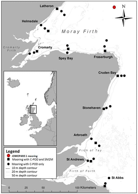
Figure 1: Geographic position of 19 ECOMMAS & JOMOPANS moorings to be retrieved in November 2019. Winter mooring to be deployed at Arbroath
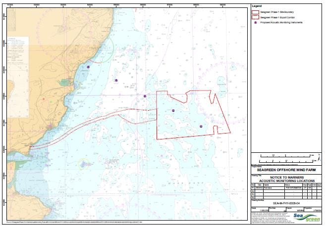
Figure 2: Locations of the 5 SSE Seagreen moorings to be retrieved and deployed
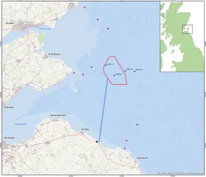
Figure 3: Locations of the 4 NNG moorings to be deployed.
Further Information:
Tags: Alba na Mara, ECOMMAS, JOMOPANS, moorings, MRV Alba na Mara, subsurface moorings

Leave a comment