
Digital
Scottish LiDAR user conference and new land and coastal LiDAR data released
October 12, 2026 by Stewart Hamilton No Comments | Category Digital Scotland, LiDAR (Light Detection and Ranging)
A joint blog by the Geographic Information Science and Analysis Team (GISAT), Rural and Environment Science and Analytical Services and the Dynamic Coast project.
We are pleased to announce a further release of data from Scotland’s national Land Light Detecting and Ranging (LiDAR) Programme alongside the release of data from the LiDAR survey of key areas of Scotland’s coast.
Data are released freely and openly under an Open Government License, and are available to download from remotesensingdata.gov.scot. Further information on the coastal surveys are available at: www.DynamicCoast.com.
Scottish LiDAR User Conference
With these data collection activities well underway, the landscape of Scotland is set to be revealed in unprecedented detail.
ClimateXChange is hosting a conference, in partnership with Scottish Government, to support the growing network of Scottish LiDAR users across government, agencies, business and research. This event is a unique opportunity for knowledge exchange and networking, focusing on the potential of high-resolution LiDAR data in protecting Scotland’s landscapes.
Register here to connect, learn, and leverage the most detailed map of Scotland ever created – in Edinburgh on Wednesday 2 December 2026
Land LiDAR data release
A further 8 survey blocks totalling around 5,200 square kilometres (6.7%) of Scotland’s land mass have been released from the Scottish National LiDAR Programme, bringing the total coverage to almost 10% of Scotland.
High resolution height data has been collected covering several mainland areas including parts of Aberdeenshire, Dumfries and Galloway and Fife, as well as the islands of Coll, Tiree and the Small Isles, with several of these being laser scanned for the very first time.
Our flights have covered around a third of Scotland’s land area. Further data releases are expected at approximately 6-month intervals through the programme as we build up a national dataset.
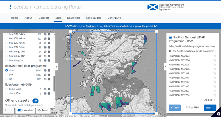
Figure 1: Land LiDAR data (blue and green areas) available at: remotesensingdata.gov.scot
Coastal LiDAR data release
A total of 792 square kilometres of coastal LiDAR data have been released. In February and March 2026, coastal surveys were collected during periods of low tides to capture the foreshore and a 1km coastal strip.
Our use of LiDAR data
Coastal datasets are essential to identify coastal erosion and accretion. They support local authorities in the development of Coastal Change Adaptation Plans and contribute to objectives set out in the third Scottish National Adaptation Plan (SNAP3).
Figure 2 shows an oblique view of the protective dunes at Montrose (Angus), with the surface coloured to depict the topographic changes identified by the coastal LiDAR survey in 2026, compared with a survey in 2024. Red areas on the beach depict 1.5m of lowering and up to 6m of lowering on the dune edge, whilst green areas on the beach have risen 0.7m.
The coastal LiDAR survey will be invaluable for assessing and informing our management of coastal change in Scotland. Work is also underway to effectively utilise the terrestrial LiDAR data for mapping the state of Scotland’s peatlands, woodlands and forests. Such mapping will help determine and support progress towards national climate, tree planting and nature restoration objectives
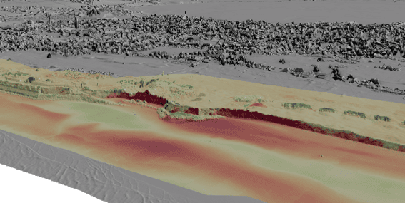
Figure 2: oblique view of LiDAR data for Montrose links protecting the town, showing vertical changes to the surface between 2024 and 2026.
A Collaborative Effort
Our LiDAR collections are the result of collaboration across government. Support for research and developing use cases is provided under the Environment, Natural Resources and Agriculture Research Programme.
The Scottish Land LiDAR programme is funded jointly by the Scottish Government (including Agriculture and Rural Economy, Environment and Forestry, RESAS, Agricultural Reform Programme and Digital), SEPA, FLS, NatureScot, Scottish Water and Scottish Forestry. Rural and Environment Science and Analytical Services (RESAS) and Digital teams have worked collaboratively with UK Government Digital Services, who have provided our mechanism for data collection through the Aerial Photography for Great Britain (APGB) Project.
The Scottish Government funded Dynamic Coast project have worked collaboratively with the Land LiDAR Programme and the coastal survey was funded by the Scottish Government (Environmental Quality and Resilience) Coastal Change Adaptation Fund.
Previous blogs on this topic
January 2026: Scotland’s LiDAR revolution: First data release to reveal Scotland’s landscape in unprecedented detail
October 2025: Mapping the Future: Scotland’s LiDAR Revolution
Get in touch at: GIS@gov.scot
Tags: Digital Scotland, LiDAR data, Scottish Land LiDAR Programme
 RSS
RSS Email
Email
Leave a comment