
Marine
MRV Scotia: survey 1115S Programme
August 18, 2015 by Marine Directorate Communications No Comments | Category Compliance, Marine Directorate general, Marine Directorate Science, Research Vessel Surveys
Rockall Haddock Survey
Duration: 23 August – 3 September 2015
Fishing Gear:
GOV Trawl (BT 137) with ground gear D
Other Gear:
CTD – Seabird 19+
Day and Van Veen grabs
Objectives:
- To undertake the bottom trawl survey of haddock on Rockall Bank to a depth of 350 m;
- To deploy a CTD at selected trawl stations to collect temperature and salinity profiles;
- To collect samples (genetics and otoliths) for selected species for population studies;
- To collect sediment samples at selected stations;
- To record marine litter at each station for MSFD.
Procedure:
The primary objective of this part of the survey is to assess the state of the haddock stock on the Rockall Plateau. The Rockall haddock surveys employs a semi random stratified survey design comprising four sampling strata separated according to depth. Sampling intensity within each of the four strata reflects the fish density observed in each of these during previous surveys. Trawling will be carried out during the hours of daylight at randomly selected locations within the 350 m contour. Forty primary tow positions have been generated and their allocation within each depth stratum is displayed in Figure 1. The number of stations within each depth strata is as follows: four stations at 0-150 m, 20 stations at 150-200 m, 11 stations at 200-250 m and five stations at 250-350 m. Where time allows additional hauls will be conducted outside our strata (at depth below 350 m). The positions of these will be influenced by trawls undertaken in the April 2015 Rockall monkfish survey where haddock were found. A further 22 secondary stations across the various strata have been generated to provide alternatives should any primary station prove unfishable.
One haul of 30 minutes duration will be made at each sampling station. Daily start times for survey stations will be at approximately 0600 hours and continue until approximately 2000 hours. The Scanmar system will be used to monitor wing spread, door spread and distance covered during each haul. A bottom contact sensor will be mounted on the footrope to record the distance of the trawl off the seabed. Catches will be worked up according to the protocols for International Bottom Trawl Surveys. A CTD will be deployed at selected trawl stations.
At night sediment samples will be collected using Day or Van Veen grabs. The samples positions will be decided on a day to day basis and will be influenced by vessel location at the end of each trawling period.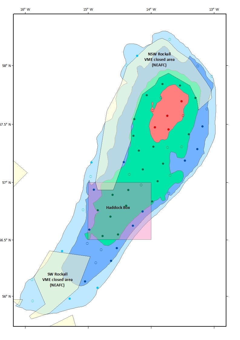
Figure 1: Survey map with stations of Rockall bank. Red stratum = 0-150 m depth, green stratum = 150-200 m, blue stratum = 200-250 m and light-blue stratum = 250-350 m. Boxes/polygons represent restricted or closed areas. Closed circles = primary haul positions, open circles = secondary haul positions.

Leave a comment