
Marine
MRV Scotia: Survey 1315S Programme
September 17, 2015 by Marine Directorate Communications No Comments | Category Compliance, Marine Directorate general, Marine Directorate Science, Oceanography, Research Vessel Surveys
Gear:
Sea-Bird CTDs, ADCPs and current meter instrumentation, water filtering equipment (x2), centrifuge equipment (HWU), bacteria sampling equipment (HWU), sediment sampling equipment (UoA), mooring equipment, recovery trawl, drifters, sediment grabs (Van Veen / Day) and sediment corers (MSS / UoA).
Objectives:
- Test the CTD in the Buchan Deep off Peterhead. Collect water samples for salinity sub-standards (12×5 litre – 4 crates of salinities).
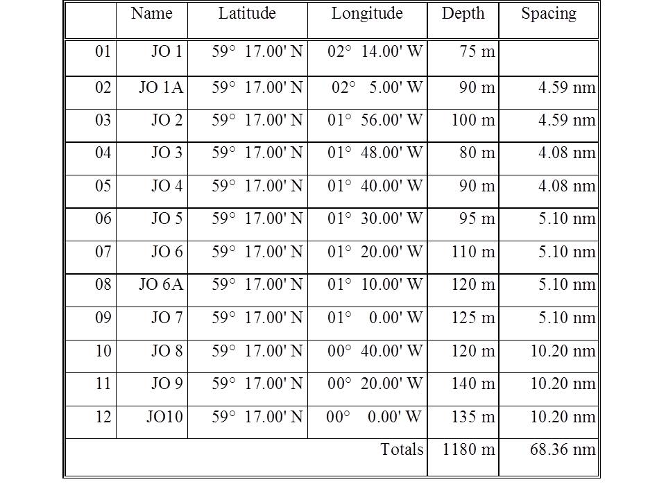
- Perform hydrographic sampling along the JONSIS long term monitoring section in the northern North Sea.
- Perform CTD stations at the ADCP moorings on the cross shelf line adjacent to the Fair Isle – Munken section.
- Recover and download the data recovered from the one ADCP moorings deployed on the cross shelf section, adjacent to the Fair Isle – Munken section, during 2014. (Note that an additional two recoveries may be required if there are any concerns about the condition of the recovered mooring). Redeploy the mooring.
- Deploy one new ADCP moorings in a trawlproof frame at a position on Fair Isle – Munken section.
- Perform hydrographic sampling along the long term monitoring Faroe-Shetland Channel sections, Fair Isle – Munken and Nolso – Flugga.
- Take water samples for long term storage at Fair Isle – Munken section stations FIM-01 and FIM-06.
- Take water samples for bacteria analysis at FIM03, FIM06a, FIM08, NOL07, NOL08 and SEFOS (b/w NOL03 and NOL03a).
- Take sediment samples using the Maxi-corer at or near a number of the Nolso – Flugga section stations. This will include some time for training on coring/sampling procedures for staff unfamiliar in its operation.
- Take micro plastic water samples at a number of locations.
- Deploy drifters on the Shetland Shelf for the SAMS aquaculture modelling experiment. Perform CTD stations at the shelf edge to determine structure prior to deploying drifters.
- Perform a number of other hydrographic sections if time allows. Namely: Repeat of NOL and FIM sections. Survey of Shetland/Orkney waters for model validation studies.
Procedure:
On sailing from Aberdeen Scotia will make passage to the start of the JONSIS long term monitoring section to commence sampling with the CTD and carousel water sampler. On route test deployments of the CTD and carousel will take place around the Buchan Deep, using the newly developed deployment procedures (10 m soak). Sea water samples will be collected to form a set of salinity sub-standards used in salinity analysis.
On completion of the JONSIS section passage will be made to the start of the ADCP line across the shelf edge adjacent to the Fair Isle – Munken (FIM) section and the CTD will be deployed at each mooring location.
After the completion of all CTD profiles, the ADCP mooring at NWSO will be recovered. On this trip only one mooring is planned for recovery, however, we will carry enough equipment to recover and redeploy all moorings in the event that the condition of the recovered mooring suggests this is necessary. The ADCP instrumentation data will be downloaded and instruments and mooring refurbished on route to the new deployments positions at NWSL. A new mooring in a trawl proof frame will be deployed on the line. CTD dips will again be done at the mooring positions.
Scotia will then make her way to the start of the FIM section for the long term monitoring samples and CTD profiles to be taken. Thereafter, Scotia will make way to the area of the Nolso-Flugga (NOL) section.
During CTD and water sampling of the FIM and NOL long term monitoring sections, grab samples and water samples will be taken for University of St Andrews, University of Aberdeen and the Heriot-Watt University visiting scientists. Micro plastic samples will be taken opportunistically through the survey.
After completion of the FIM section, Scotia will return to the Shetland shelf in order to undertake a set of close CTD sections in support of the aquaculture deployments. The drifters will be deployed in a pre-planned pattern, with the locations on the shelf to be determined after inspection of satellite imagery. After this, a sequence of 16 surface drifters will be deployed at positions to be determined. The drifters do not need to be recovered.
Any remaining time will be spent repeating the stations of the Fair Isle – Munken sections and Nolso-Flugga sections, carrying out CTD sampling on the shelf edge between Orkney and Shetland, and testing the operation of the Maxi-Corer.
Mooring Positions (Recovery):
Note that positions are target positions. For recovery purposes, actual deployed positions are to be found on mooring log sheets. Mooring operations often involve assistance from crew members, to be sure that everyone is clear about procedures a briefing with officers/crew and scientists will be scheduled prior to operations commencing.
New deployment
- NWSL – 60° 52.63’ N 005° 31.53’ W (moored ADCP in seabed frame, trawl-resistant, water depth 472 m).
For service (Recovery and Re-deployment)
- NWSO – 60° 41.49’ N 005° 04.12’ W (moored ADCP in floatation collar, up to 400 m of wire, water depth 918 m).
To be left deployed (unless necessary to service wires)
- NWSP – 60° 37.76’ N 004° 55.05’ W (moored ADCP in floatation collar, up to 400 m of wire, water depth 1019 m).
- NWSN – 60° 45.22’ N 005° 13.22’ W (moored ADCP in floatation collar, up to 200 m of wire, water depth 865 m).
The thermosalinograph will be run throughout the survey.
(NOTE: The survey will take Scotia into the Foinaven Development Area. This is now standard practice and normal on-site communications will be established with the Foinaven coordinating officer).
CTD lines and mooring locations
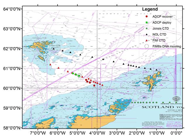
JONSIS Line

Nolso-Flugga
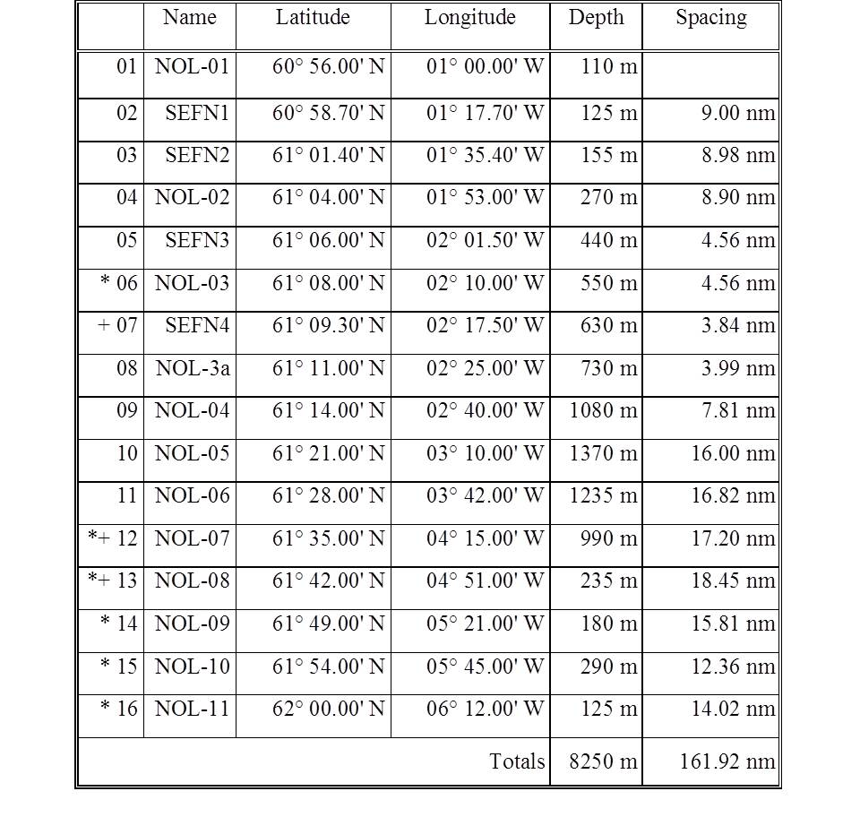
+ Water samples to be taken for HWU

Leave a comment