
Marine
MRV Scotia: Survey 1016S Programme
July 18, 2016 by Marine Directorate Communications No Comments | Category Compliance, Marine Directorate general, Marine Directorate Science, Marine Directorate Surveys
Duration: 18 July – 3 August 2016
Gear:
- Sonardyne Ranger II USBL system
- Sonardyne directional / omni-directional transponders (x3)
- TV drop frame and wiring harness
- TV sledge and wiring harness
- SEA LED lights (x4)
- SeaLaser (x4)
- Kongsberg OE14-408 digital camera system
- Kongsberg OE14-366 digital still camera system
- Kongsberg OE14-366 TV camera system
- SUBC 1-CAM Alpha HD camera system
- mini Hammon grab
- 0.25m2 USNEL BSL Box core
Background:
Marine Scotland Science (MSS) and the Joint Nature Conservation Committee (JNCC) will undertake an offshore seabed survey of Geikie Slide and Hebridean Slope (GSH hereafter) Scottish Nature Conservation Marine Protected Area (NCMPA) on the Marine Research Vessel (MRV) Scotia (Figure 1). Located to the north-west of Scotland, Geikie Slide and the Hebridean Slope (GSH) NCMPA follows the descent of the seabed from a depth of 113m on the Hebridean continental shelf, into the deep-sea of the Rockall Trough to a depth of 1757m. Habitats within the MPA vary down the slope with the descent into deeper water. The MPA represents the variation in sandy, muddy and gravelly habitat types present, and the animal communities they support.
Objectives:
- Conduct a Type 1 monitoring survey of GSH focusing sampling within nested boxes positioned to allow for sampling to occur across the range of depths, biological zones and proposed management measures at the site.
- Conduct Type 3 sampling within a nested box outside of GSH at the same depth and of similar current fishing pressure as a nested box within a proposed management measures area in GSH.
- Conduct a camera chariot transect and benthic sampling survey within GSH (including within area of existing MBES bathymetry and backscatter data) to gather further information on the distribution of broadscale habitats present within the site.
Narrative:
After completion of safety drills and exercises, Scotia will proceed westwards towards the Geikie Slide and Hebridean Slope survey area (GSH), stopping at a suitable location (Buchan Deeps) to undertake gear testing on route. The vessel will then make passage to the work site and commence sampling with the 0.25m2 box core and TV frames on the stations detailed in Figure 2 and in Table 1 and 2. In total, 108 TV, sediment and benthic infaunal samples will be collected from the GSH site. Off-site contingency options have been identified following discussion with Scottish Natural Heritage (SNH). These sampling stations may be visited if work is disrupted by prolonged bad weather.
***********************
Further Information:
Figure 1: Survey Location
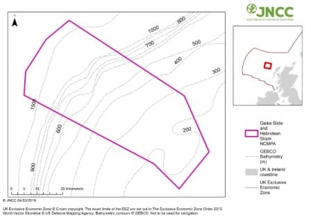
Figure 2: Sampling locations
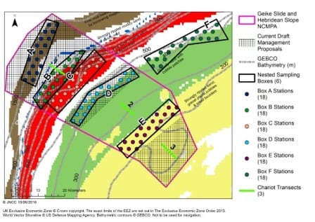
Table 1: Station Positions

Table 2: Chariot Transects


Leave a comment