Marine
Pipelines, Camera, Action
May 25, 2018 by Marine Directorate Communications No Comments | Category Marine Directorate general, Marine Directorate Science, Marine Directorate Surveys, Research Vessel Surveys
Survey: 0718S
Duration: 18- 31 May 2018
Gear:
- Day grabs
- TV drop frame with lasers
- Aarmoured cable
- Multibeam echosounder system
- EK 60
- Conductivity, Pressure & Depth (CTD) device
- Acoustic Doppler Current Profiler (VM-ADCP)
- Fish cages
- PT160 (trawl)
Objectives:
- To assess the hydrographic influences on the aggregation of fish around surface laid oil and gas pipelines.
- To assess the handling and performance of a benthic time lapse camera.
Procedure
Before making passage to the pipeline stations, MRV Scotia will need to calibrate the EK60 and MBES in Scapa Flow. The nature of the survey work will be heavily dependent on the prevailing weather conditions encountered.
The survey techniques are no different to previous surveys conducted by Marine Scotland Science (MSS) using Scotia albeit on a more localised scale. The proposed survey is based on two parts:
- The deployment and recovery of a time lapse camera for the duration of the survey; and
- The collection of hydrographic and fisheries acoustic data over 12 or 24 hour periods from several pipeline stations.
Time Lapse Camera
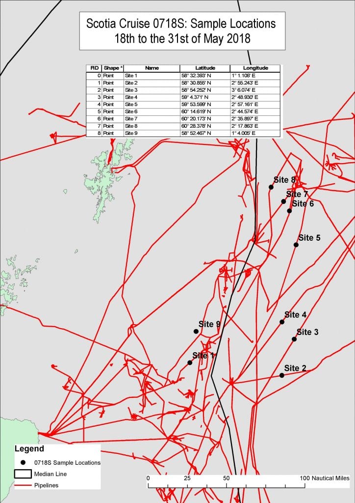
The time lapse camera will be placed on the seabed at the beginning of the survey in the vicinity of the pipeline stations and surface marked with a buoy (Site 9 Figure 2). On completion of the survey the camera will be recovered.
Multibeam Bathymetry
A sound velocity profile (SVP) will be collected 500 m outside of the survey location. On completion of the SVP, MRV Scotia will complete a multibeam swathe along the length of the targeted pipeline. Survey speed will be 4 knots. The output will be checked for any anomalous features that could interact with other survey equipment. If features are identified, MRV Scotia will relocate in the immediate area and repeat the multibeam swathe along the pipeline until a suitable length of pipeline is identified.
Trawling and Fish Cages
Trawling using the PT160 may be required to catch fish needed to bait the fish cages. Cages will be deployed at the mid-point and the end-point of one transect. They will remain in-situ until the EK60 survey is completed. Trawling with the PT160 along, but clear of, the pipeline and end transect will be conducted after the recovery of the fish cages.
EK60, CTD, VM-ADCP, Multibeam Through Water Column and Seabed Video Footage
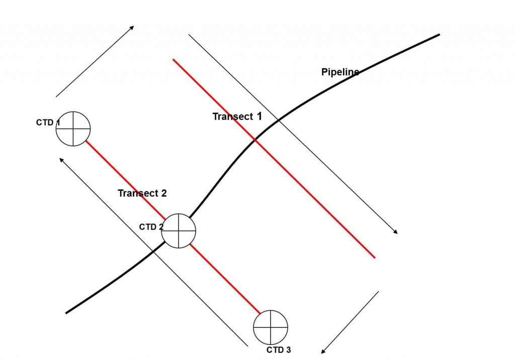
The collection of fisheries acoustic data will involve two parallel transects 5 km in length and 1 km apart running perpendicular to a pipeline (Figure 1).
Survey speeds during use of the EK60 will be a maximum of 8 knots while VM-ADCP and multibeam data will be collected at 5 knots. Each of the techniques will be collected independently due to potential interference between the different pieces of equipment.
CTD measurements will be made every three hours at the ends and centre point of a transect. Water samples will also be collected for chlorophyll, salinity and nutrients using the vessel’s non-toxic water supply and reversing bottles attached to the CTD.
Multibeam transects will be run along the pipeline to collect through water column data for assessing the dimensions of fish aggregations.
Video footage using a drop-frame camera will be collected from the top, middle and bottom stations for each transect. The multibeam data will be assessed to identify changes in the seabed substrate. The substrates will be ground-truthed using a drop-frame camera. The drop-frame will be deployed 500 m from the pipeline off the stern of the vessel using an armoured cable. The drop-frame will be kept at 1.5 m above the seabed/pipeline and towed using the vessel’s bow thrusters at a speed of 1 knot or less (0.5 m per second) on a course perpendicular to the pipeline. Video capability on the drop-frame will be vertically mounted.
Tags: MRV Scotia, research, science


Leave a comment