
Marine
Demeral Trawling Survey on the West Coast
November 6, 2019 by Marine Directorate Communications No Comments | Category Marine Directorate general, Marine Directorate Science, Research Vessel Surveys
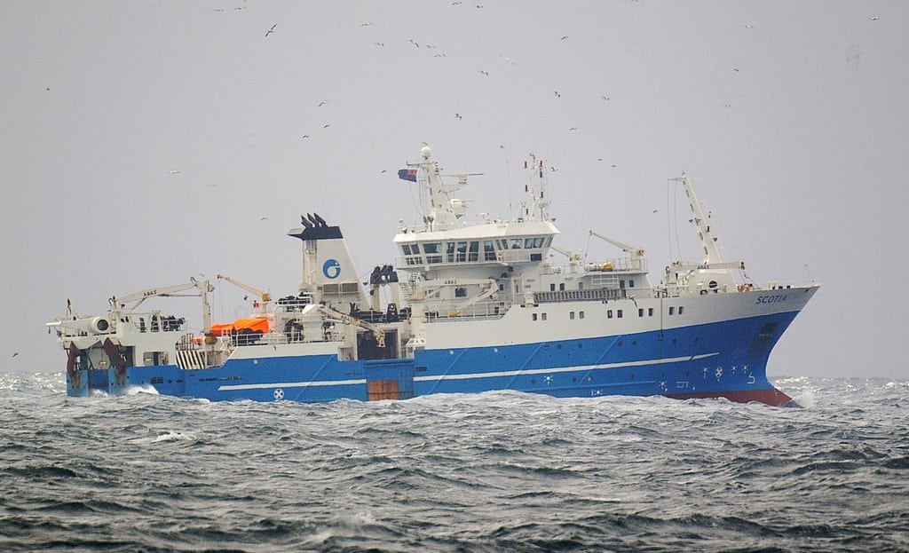
MRV Scotia
Survey: 1719S
Duration: 4 – 25 November 2019
Fishing Gear: GOV Trawl (BT137) and ground gear D (hoppers).
Objectives:
- Participate in the International Council for the Exploration of the Sea (ICES) coordinated western division demersal trawling survey.
- Obtain temperature and salinity data profiles at each trawling position.
- Collect additional biological data in connection with the EU Data Collection Framework (DCF).
- Retrieval and redeployment of Collaborative Oceanography and Monitoring for Protected Areas and Species (COMPASS) mooring at Stanton Bank deployed during previous survey.
Procedures:
MRV Scotia will sail on 4 November and (after all safety drills and shakedown trawling) commence fishing operations the following morning on stations to the west of the Orkneys. Weather conditions at the time will determine the exact start area. Survey schedule and operations will be decided by Scientist-in-Charge (SIC) after daily consultation with Fishing Master and Captain.
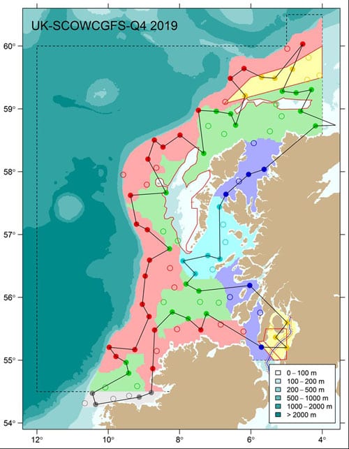
Figure 1. 1719S trawl locations. Note – tow positions for each core station (solid circle) and alternative/additional positions (empty circles) will be added as time allows.
Trawling:
This is a random-stratified survey design with trawl stations being distributed within 12 predefined strata covering the sampling area (Figure 1). A more detailed map showing the Clyde trawl stations in relation to the underwater cable installed in 2017 is provided in Figure 2. A total of 60 primary and 38 secondary stations have been generated. The intention is for 60 trawls to be undertaken on suitable ground as near to the specified primary sampling positions (Table 1) as is practicable, and where possible within a radius of five nautical miles of the sampling position. In the event that trawling is not possible within 5 nm of any primary station then the nearest appropriate secondary station will be used. Hauls will be of 30 minutes duration unless circumstances dictate otherwise. Where possible, fishing operations will be restricted to daylight hours. Exact start and finish times will vary slightly according to geographical location.
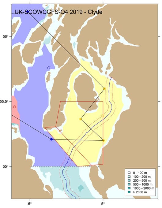
Figure 2. Map showing Clyde stations in relation to cable installed in 2017. Note – The blue line shows the location of the deep-water cable installed in 2017 and the red dotted line shows the ± 1.5 nmi safety area around the cable.
The Scanmar system will be used to monitor the headline height, wing spread and door spread for each haul. Bottom contact data from each trawl will also be collected using the NOAA bottom contact sensor, which will be mounted on a bar in the middle of the ground-gear. In addition to the routine sampling, biological data will be collected for target species in line with the EU data regulation.
Fish Sampling:
All fish will be processed in accordance with the protocols as described in the Manual of the IBTS North Eastern Atlantic Surveys. Series of ICES Survey Protocols SISP 15. 92 pp.
Hydrography Sampling:
Conductivity Temperature Depth (CTD) casts will be taken at each trawl station, weather permitting.
COMPASS Moorings:
During the survey one day will be allocated to the retrieval and redeployment of two acoustic moorings deployed during a previous survey. The intention is to undertake this objective during Part 1 of the survey with an acoustic release system being deployed from the vessels side deck to trigger the moorings.
Table 1: 1719S – Position of primary sampling stations
| Station | lat | lon | deglat | deglon | stratum |
| 1 | 58.96247 | -4.607729 | 5857.75N | 0436.46W | green1 |
| 2 | 59.3044 | -4.30137 | 5918.26N | 0418.08W | green1 |
| 3 | 59.25443 | -4.732363 | 5915.27N | 0443.94W | green1 |
| 4 | 59.28047 | -5.119988 | 5916.83N | 0507.20W | green1 |
| 5 | 59.63196 | -4.834488 | 5937.92N | 0450.07W | windsock |
| 6 | 60.03191 | -4.545194 | 6001.91N | 0432.71W | red1 |
| 7 | 59.48743 | -5.328187 | 5929.25N | 0519.69W | windsock |
| 8 | 59.50362 | -5.699959 | 5930.22N | 0542.00W | windsock |
| 9 | 59.64184 | -6.193042 | 5938.51N | 0611.58W | red1 |
| 10 | 59.48501 | -6.576728 | 5929.10N | 0634.60W | red1 |
| 11 | 59.21047 | -6.160272 | 5912.63N | 0609.62W | windsock |
| 12 | 58.74089 | -6.429035 | 5844.45N | 0625.74W | green1 |
| 13 | 58.92074 | -6.565814 | 5855.24N | 0633.95W | green1 |
| 14 | 58.96038 | -6.969687 | 5857.62N | 0658.18W | green1 |
| 15 | 58.9769 | -7.473466 | 5858.61N | 0728.41W | red1 |
| 16 | 58.2913 | -7.32209 | 5817.48N | 0719.33W | green1 |
| 17 | 58.58162 | -7.988137 | 5834.90N | 0759.29W | red1 |
| 18 | 58.39124 | -8.466181 | 5823.47N | 0827.97W | red1 |
| 19 | 58.5036 | -8.70768 | 5830.22N | 0842.46W | red1 |
| 20 | 58.20023 | -8.886268 | 5812.01N | 0853.18W | red1 |
| 21 | 57.66401 | -8.378741 | 5739.84N | 0822.72W | green2 |
| 22 | 57.62313 | -9.37477 | 5737.39N | 0922.49W | red1 |
| 23 | 57.16478 | -9.20848 | 5709.89N | 0912.51W | red2 |
| 24 | 57.07604 | -8.903222 | 5704.56N | 0854.19W | red2 |
| 25 | 56.77223 | -8.283156 | 5646.33N | 0816.99W | green2 |
| 26 | 56.59257 | -8.842584 | 5635.55N | 0850.56W | red2 |
| 27 | 56.33942 | -8.96371 | 5620.37N | 0857.82W | red2 |
| 28 | 55.88948 | -9.045951 | 5553.37N | 0902.76W | red2 |
| 29 | 55.69321 | -8.855828 | 5541.59N | 0851.35W | red2 |
| 30 | 55.16835 | -9.2548 | 5510.10N | 0915.29W | red2 |
| 31 | 55.20564 | -9.972894 | 5512.34N | 0958.37W | red2 |
| 32 | 55.05976 | -9.784037 | 5503.59N | 0947.04W | red2 |
| 33 | 54.96405 | -9.499039 | 5457.84N | 0929.94W | green4 |
| 34 | 54.7919 | -9.428163 | 5447.51N | 0925.69W | green4 |
| 35 | 54.47329 | -10.444974 | 5428.40N | 1026.70W | gray |
| 36 | 54.29499 | -10.352855 | 5417.70N | 1021.17W | gray |
| 37 | 54.413 | -9.131841 | 5424.78N | 0907.91W | gray |
| 38 | 54.4843 | -8.792802 | 5429.06N | 0847.57W | gray |
| 39 | 54.86623 | -8.753432 | 5451.97N | 0845.21W | red2 |
| 40 | 55.47931 | -8.700307 | 5528.76N | 0842.02W | red2 |
| 41 | 55.7661 | -8.204705 | 5545.97N | 0812.28W | green3 |
| 42 | 55.66018 | -7.7588 | 5539.61N | 0745.53W | green3 |
| 43 | 55.48171 | -7.402395 | 5528.90N | 0724.14W | red2 |
| 44 | 55.73953 | -7.248396 | 5544.37N | 0714.90W | green3 |
| 45 | 55.20804 | -5.705191 | 5512.48N | 0542.31W | blue2 |
| 46 | 55.19889 | -4.993599 | 5511.93N | 0459.62W | clyde |
| 47 | 55.36414 | -5.306141 | 5521.85N | 0518.37W | clyde |
| 48 | 55.5974 | -4.982199 | 5535.84N | 0458.93W | clyde |
| 49 | 56.1898 | -6.032125 | 5611.39N | 0601.93W | blue2 |
| 50 | 56.10104 | -7.45851 | 5606.06N | 0727.51W | green3 |
| 51 | 56.21185 | -7.819209 | 5612.71N | 0749.15W | green3 |
| 52 | 56.37653 | -7.55737 | 5622.59N | 0733.44W | lightblue |
| 53 | 56.57917 | -7.905759 | 5634.75N | 0754.35W | lightblue |
| 54 | 56.66497 | -7.208751 | 5639.90N | 0712.53W | lightblue |
| 55 | 56.60989 | -6.868622 | 5636.59N | 0652.12W | lightblue |
| 56 | 57.43943 | -6.883278 | 5726.37N | 0653.00W | lightblue |
| 57 | 57.64108 | -6.700875 | 5738.46N | 0642.05W | blue1 |
| 58 | 57.95637 | -6.064734 | 5757.38N | 0603.88W | blue1 |
| 59 | 58.03786 | -5.631351 | 5802.27N | 0537.88W | blue1 |
| 60 | 58.72933 | -4.18985 | 5843.76N | 0411.39W | green1 |
Additional Information:
- Marine Scotland Website
- MRV Scotia Topic Sheet
- Previous ICES Surveys
- MRV Scotia 2019 Blog Posts
- International Council for the Exploration of the Sea (ICES) Website
- COMPASS Website
Tags: COMPASS, demersal trawl survey, hydrography, ICES, moorings, MRV Scotia, oceanography, research, samples, sampling, science, Scotia, Stanton Bank, STEM, Survey, trawling

Leave a comment