
Marine
MRV Alba na Mara: Survey 0915A Programme
June 10, 2015 by Marine Directorate Communications No Comments | Category Compliance, Marine Directorate general, Marine Directorate Science, Research Vessel Surveys
Duration: 10-30 June 2015
Background:
The central objective of EIWiF is to monitor the broader ecological environmental impact of offshore renewable developments. This work will concentrate on the developments proposed east of the Firth of Forth estuary. Several potential impacts have been identified in the scientific literature, varying from seemingly negative to seemingly positive impacts, but these impacts are often highly nuanced and have been difficult to detect. EIWiF maximises the power to detect effects by focusing upon components of the ecosystem where impacts might be seen to be greatest: i.e. in fish, seabird, epifaunal and infaunal communities. The project also utilises long-running, historical data collected over the past 23 years by MSS. The study will combine these historical data with targeted, pre- and post- impact surveys in a before/after control/impact (BACI) framework to document changes in community structure.
Gear:
| 10–15 June | 15–22 June | 22–30 June |
| PT154 | 2m beam trawl | 3 x fish traps + accessories |
| Birdwatching chairs | 4ft modified scallop (sandeel) dredge | 2 x Day grab + table + wts + square sieve (3 x 0.5mm) |
| Nephrops sorting table | Scanmar depth unit | Round sieve table. Circular sieves: 5mm, 1mm |
| BT158 + spares or patchings | Pyramid frame and underwater video camera kit | |
| Scanmar depth, head and wing units | Pyramid frame calibration mesh (2 x wire panels) |
Objectives:
- To undertake an acoustic survey of sandeels and clupeid fish in the water column using 38 and 120 kHz.
- To conduct RoxAnn survey of the substrate along all acoustic survey tracks.
- To conduct seabirds-at-sea survey and a survey of marine mammals along the acoustic survey track.
- To assess abundance, length-frequency-distribution and age- weight-at-length of demersal fish predators at eight fixed stations in the Firth of Forth area by demersal trawl survey.
- To assess abundance, length-frequency-distribution and age- weight-at-length of demersal fish, and abundance and total biomass of benthic invertebrates, in the Neart na Gaoithe development site and three further control areas.
- To assess abundance, length-frequency-distribution and age- weight-at-length of sandeels in the Neart na Gaoithe development site and three further control areas.
- To conduct a UW TV survey of stations in the Neart na Gaoithe development site and three further control areas.
- To conduct a survey of demersal fish using fish traps in the Neart na Gaoithe development site and three further control areas.
Broad Scale Survey:
From 11-15 June (provisional), 0915A will survey areas around the proposed Neart na Gaoithe and Inch Cape developments that tie in with MSS’s long term monitoring in these waters. The survey will operate from 04:00 to 16:00 hours (all times UTC) during this period. Five transects (Figure 1) will be surveyed acoustically at 38 and 120 kHz to examine the abundance of sandeels and clupeid fish in the water column. Concentrations of fish will be sampled using the PT154 pelagic trawl. Species composition and length frequency distributions of fish caught will be determined. Sub-samples will be weighed and their otoliths removed to establish length-weight relationships and age composition. RoxAnn data will be collected throughout the acoustic transects to support the development of seabed sediment maps. Seabirds at sea data will also be collected simultaneously using standard transect census methods to determine the numbers of seabirds using the study area on a daily basis, and their distribution over the area. Following the completion of the acoustic survey it is hoped that prior to 15 June a total of eight demersal trawl stations will be fished using the BT158 (Figure 2). To this end, the vessel will require a port call in order to exchange the PT154 doors. All eight demersal stations have been fished in previous PICMATOP surveys, supporting a database extending back to 1997. Deck operations during this period will switch to 07:00 hours to 19:00 hours. Each catch will be worked up to determine numbers at length of all species caught. Trawl performance metrics will be monitored using Scanmar equipment to enable swept area to be determined. Catch size can then be converted to point density estimates. Size stratified samples of cod, haddock and whiting will be weighed to determine their length-weight relationships. The abundance and biomass of selected invertebrate species will also be recorded from the catch. On the afternoon of 15 June Alba na Mara will make way for Montrose to facilitate crew and gear changes.
Site Survey:
The vessel will return to the study site to begin the benthic survey of the Neart na Gaoithe development site and three further control areas on 16 June (Figure 3). Working between 07:00 and 15:00 hours, the vessel will sample benthic fish and invertebrate communities using the 2 m beam trawl (5 minutes duration at 1 knot). In common with the broad scale demersal survey, fish in each catch will be worked up to determine numbers at length of all species caught. Length stratified samples of cod, haddock and whiting will be weighed to determine their length-weight relationships and their otoliths retained for subsequent age analysis. The abundance and total biomass of selected invertebrate species will also be recorded from the catch. Deck operations will switch over daily at 15:00 hours, continuing until 19:00 hours, to the modified scallop dredge in order to sample sandeels from potential sites within the development and control sites (Figure 4). The dredge survey uses 10 minute deployments (at 2.5 knots) of the dredge to obtain catch-at-length data. Length stratified subsamples will be collected, weighed and their otoliths removed to establish length-weight relationships and age composition. Work will cease on the afternoon of 21 June to allow for a half-landing at Montrose on 22 June. Crew and equipment changes will again be made at this time. All trawl gear will be removed and the vessel will be set up for the UW TV survey.
The vessel will return to the study site on 23 June, working a 07:00 to 19:00 hours schedule. Photographic surveys of the seabed will be carried during the next six days, visiting stations in the development site and in the three neighbouring controls (Figure 5). The pyramid camera frame will be used to take five quadrat images at each station. Species type, species densities and substrate type will be recorded from the collected images post-survey. RoxAnn sediment data will also be collected during the TV survey. In addition to this programme of work, a series of fish traps will be deployed each morning to monitor fish aggregations. The traps target the same development and control areas surveyed in the TV survey and will be collected the next morning after a 24 hour soak-period. A possible objective will be to collect ~ 40 grab samples from areas where the renewable pilings are to be erected. This work will only proceed if the precise location of such structures is known at the time of survey. If carried out, sediment samples and benthic infaunal samples will be collected from the grabs. Infaunal samples will be stored in 10% formaldehyde solution and will be brought back to the laboratory for later analysis.
****************************
Figure 1: The broad scale study area showing the five acoustic transects (green dashed line). The sea bird survey will take place simultaneously. Proposed renewable developments (red line) and survey boxes (purple boxes) are also shown.
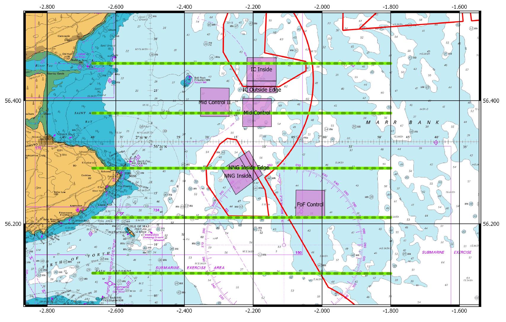
Figure 2: The eight demersal stations (red) to be sampled with the BT158 net (30 minute) during the broad-scale survey. Proposed developments are shown by red boundary.
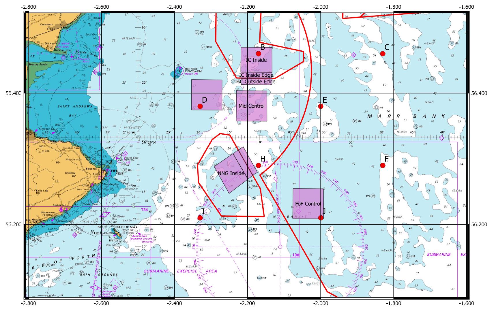
Figure 3: The approximate location (red lines) of beam trawl tows (5 minute) within the NNG development and three other controls.
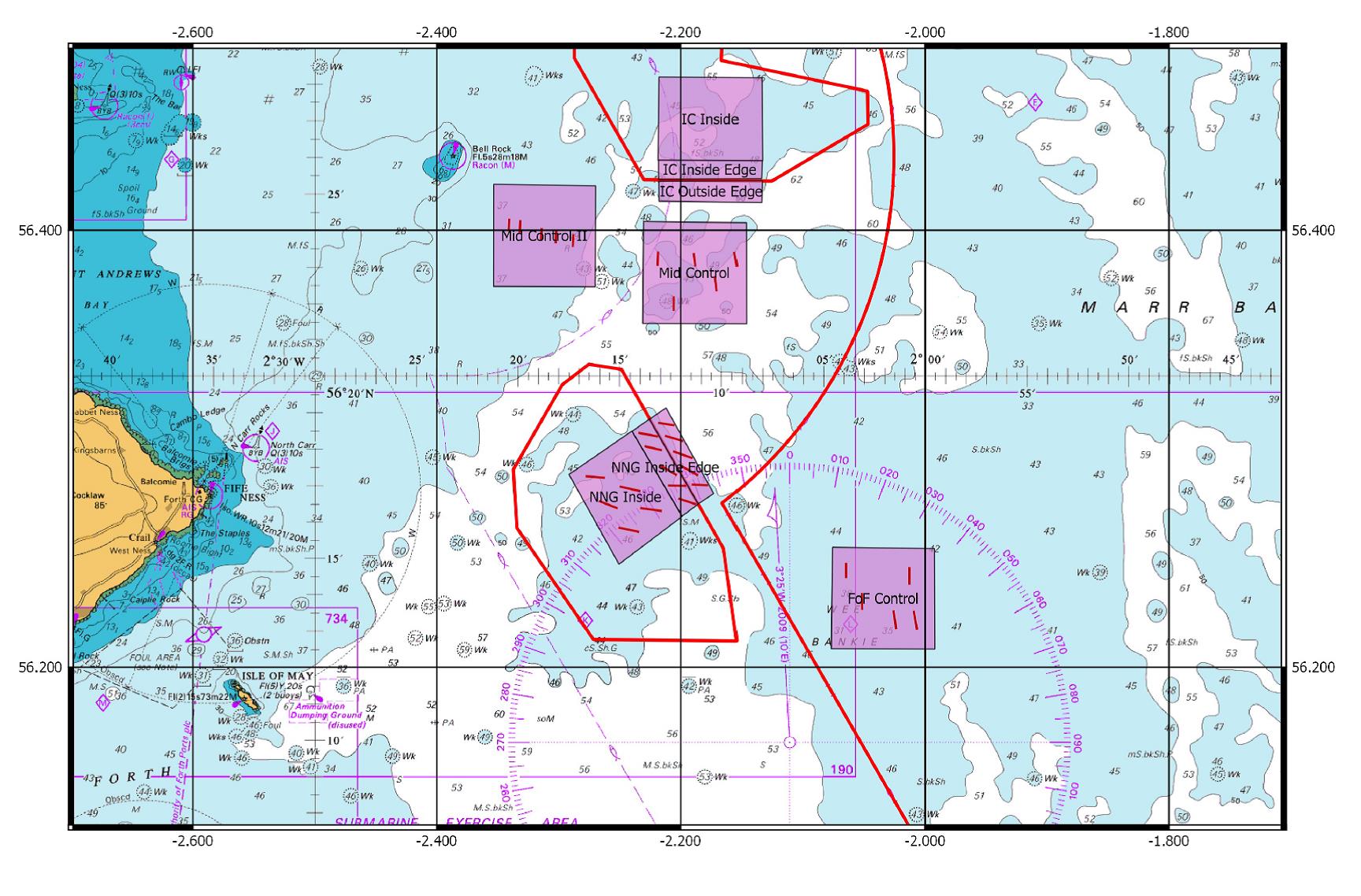
Figure 4: The position of sandeel boxes (dashed black line) to be dredged (10 minute) during the sandeel survey.
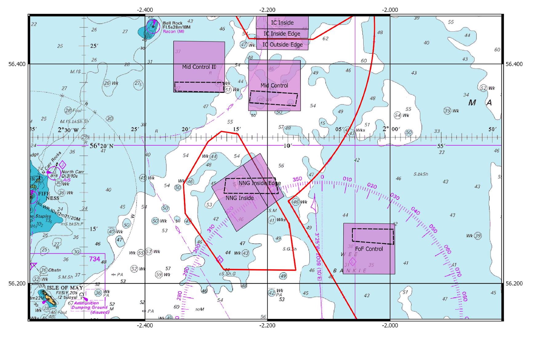
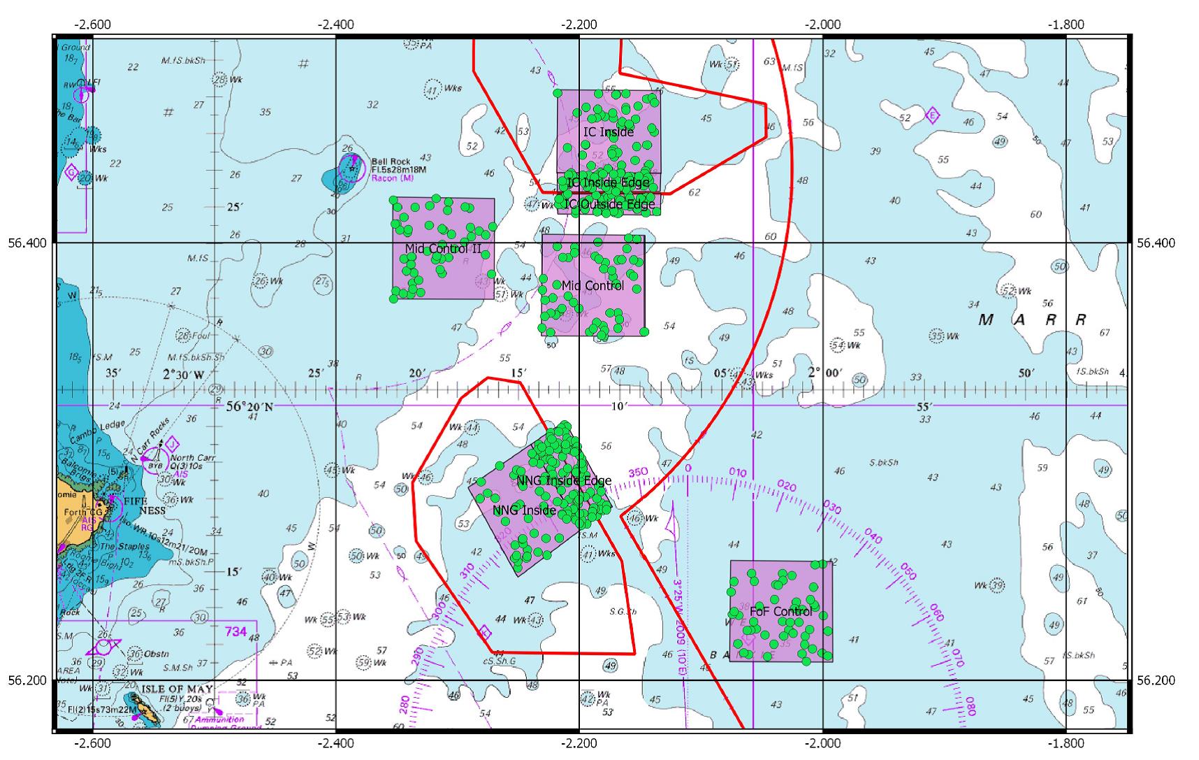
Figure 5: The location of stations (green dots) to be surveyed in the benthic TV survey. 50 stations are marked per box (150 for the three boxes in Neart na Gaoithe). The Inch Cape development to the north will not be survey during 0915a.

Leave a comment