
Marine
Surveying the German High Seas fleet in Scapa Flow
July 27, 2017 by Marine Scotland Communications 3 Comments | Category Collaborations, Marine Directorate Science, Research Vessel Surveys
 Duration: 23 – 31 July 2017
Sampling Gear
- Swathe multibeam echosounder system
- TV drop frame with armoured cable
- Scout System
- RoxAnn system
- Seatronics ROV
Project Summary
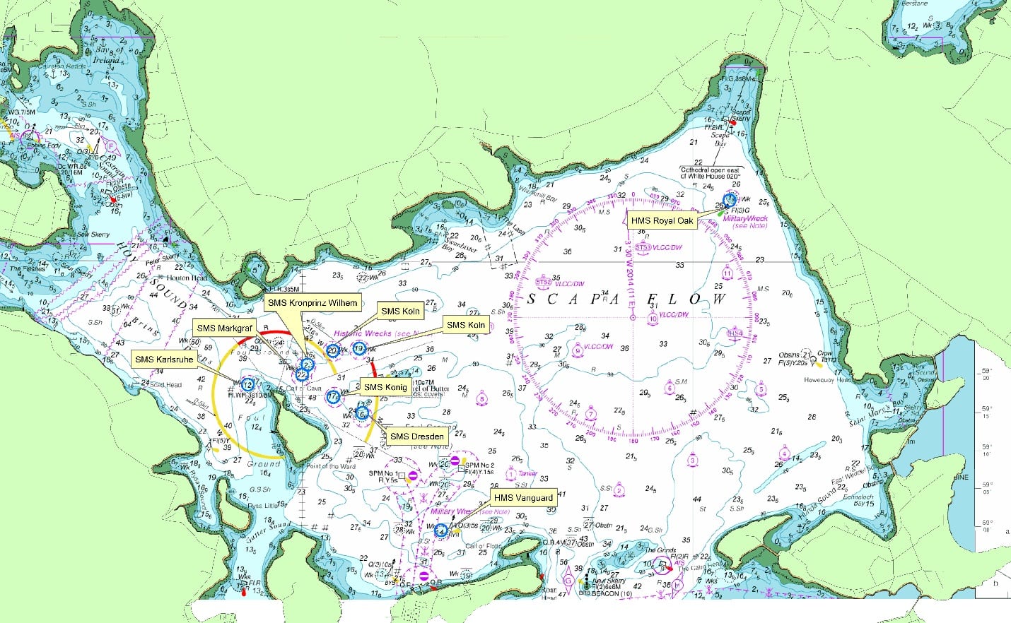
This project is a multidisciplinary collaborative project to undertake remote sensing and diver surveys of the High Seas Fleet and the War Graves HMS Hampshire, HMS Vanguard and HMS Royal Oak. Where possible, data will be also be collected of other submerged cultural heritage assets in Orkney waters.
The centenary of the High Seas Fleet will take place in 2019. This project, led by ORCA (Orkney Research Centre for Archaeology) Marine, University of the Highlands and Islands Archaeology Institute, will include universities, commercial companies and government bodies. This project will conduct archival research, marine geophysical survey, remote archaeological evaluation, and diver survey. This will establish the extent, survival and character of the remains of the wrecks in Scapa Flow, Orkney. It is planned that this will coincide with the centenary commemorations of World War One.
This survey will employ a number of methods to image the wreck sites. The scope of work will include side scan sonar, multibeam echosounder survey and Remotely Operated Vehicle (ROV). The inspection class ROV will collect video/stills and photogrammetric data. The remains of the wreck sites will not be physically disturbed by any aspect of the proposed survey.
The archival research and archaeological remote evaluation surveys that comprise this project will lead to the provision of condition monitoring data, enhanced heritage displays, data for academic research, and activities and material for public engagement.
The project lead is ORCA Marine, University of the Highlands and Islands Archaeology Institute.
- Marine Scotland vessel MRV Scotia will be the work platform for data collection. Data collection will involve Marine Scotland undertaking MBES survey, providing calibrated unprocessed raw data and camera equipment for the acquisition of data.
- Seatronics: An Acteon Company will provide ROV, positioning and photogrammetric equipment for acquisition of data.
- Historic Environment Scotland will provide guidance on marine historic assets, survey targets and specialist knowledge on the wreck sites.
- Ulster University will provide input into the specifications for data acquisition for the geophysical and ROV surveys and provide input into maritime archaeological assessment and analysis.
- Heriot-Watt University will provide input into the specifications for data acquisition for the ROV survey and undertake marine biological studies on the submerged cultural heritage assets.
- SULA Diving will provide vessel transfers, organization of diving operations and dive team, along with providing input into the specifications for data acquisition for the geophysical and ROV surveys and provide input into site assessment and analysis.
- Ministry of Defence will provide input into the specifications for data acquisition for the geophysical and ROV surveys, and specialist knowledge on the wreck sites being investigated and environmental studies of the wreck sites.
- The University of Dundee will process MBES and ROV survey data and work to produce visualisations based on the collected data. This will involve the production of 3D models of the wreck sites from the multibeam echosounder and photogrammetric data.
The project will be conducted in liaison with the Ministry of Defence, Orkney Marine Services, Orkney Marine Skippers, and relevant authorities/ marine users, ensuring appropriate permissions are obtained before the work begins. The data and project archive will be deposited with Historic Environment Scotland in accordance with the standards established by the Marine Environmental Data Information Network (MEDIN).
Procedure
On arrival to the survey site the vessel will undertake a multibeam survey of the wrecks in order of priority. Multibeam survey work will be conducted between 18:00 – 06:00 hrs with ROV operations undertaken between 06:00 – 18:00 hrs each day.
Information gathered during multibeam data collection will provide target locations for specific ROV investigation along with general mapping of each wreck site. Specific data line positions will be provided to the vessel prior to undertaking multibeam survey work.
The drop frame camera work will be used where appropriate, and as a backup for ROV operations.
The RoxAnn system will be run throughout the survey.
Tags: Scapa flow, warship, wreck

The map shows the Koln labeled twice. From other wreck maps, it appears that the easternmost of the two labels should be the Brummer.
Hi Ed, the basemap is a standardised hydrographic chart. The displayed depths are metres below chart datum (lowest astronomical tide)
The depths mentioned on the map. I assume they are in Fathoms? Not meters?