
Marine
Taking the Sea-Bird to the Faroe-Shetland Channel
December 8, 2017 by Marine Scotland Communications No Comments | Category Marine Directorate Science, Marine Directorate Surveys, Research Vessel Surveys
Duration:
8 – 18 December 2017
Gear
Sea-Bird CTD/Carousel, Plankton Nets (ARIES), water filtering equipment
Objectives
- Test the CTD in the Buchan Deep off Peterhead and test plankton crane and ARIES at an appropriate location before its first use.
- Perform routine hydrographic sampling at stations along the long term monitoring JONSIS section in the northern North Sea (Priority 1).
- Perform routine hydrographic sampling at stations along the long term monitoring Faroe-Shetland Channel section: Nolso-Flugga (Priority 1).
- Conduct combined plankton/hydrographic observations by deploying Aries in the Faroe-Shetland-Channel at selected stations on the Nolso-Flugga lines (Priority 1).
- Take nutrient, chlorophyll, TA/DIC, oxygen samples along all standard lines.
- Perform sampling along the Stonehaven AlterEco section (going west from 2° E) (Priority 1).
- Run the thermosalinograph throughout the survey.
- Perform routine hydrographic sampling at stations along the long term monitoring Faroe-Shetland Channel section Fair Isle-Munken (Priority 2).
- Conduct combined plankton/hydrographic observations by deploying Aries in the Faroe-Shetland-Channel at selected stations on the Fair Isle-Munken line (Priority 2).
- Recover one ADCP mooring at a position on Faroe-Shetland Channel Faroe-Cape Wrath (FCW/NWZ) section (NWZ-E) (Priority 3).
- Perform hydrographic sampling in the vicinity of the above ADCP mooring in order to calibrate the mooring equipment. CTD dip at mooring location with equipment (SB56 x2 and a MicroCAT) attached to carousel (Priority 3).
- If conditions in the Faroe-Shetland Channel don’t allow further work in the Faroe-Shetland Channel, conduct VMADCP/CTD work in the Moray Firth (Priority 3).
- If weather/time permits, perform a VMADCP survey on the Jonsis line (around 59° 16.96′ N, 001° 15.26′ W) (Priority 3).
- If sheltering in a suitable location around Shetland due to bad weather conduct VMADP/CTD surveys. If time/conditions allow conduct sampling along any of the following sections (in order of priority, no water sampling):
- East of Shetland 2
- East of Shetland 1
- West of Shetland 2
- North of Shetland 1
General Procedure
After departing Aberdeen and completing appropriate drills, the vessel will proceed to the eastern end of the JONSIS line and complete hydrographic stations in a westerly direction (Table 1, Figure 1). On route to JONSIS test deployments of the CTD and carousel will take place around the Buchan Deep. A test of the ARIES system will also be undertaken.
The vessel will then proceed to the Faroe-Shetland Channel. We will commence hydrographic sampling and ARIES sampling at selected stations along the Nolso Flugga survey line (Table 2, Figure 1).
On completion of the Nolso Flugga line, if time allows, the vessel will proceed to conduct hydrographic sampling and ARIES sampling at selected stations on the Fair Isle-Munken survey line (Table 4, Figure 1). Towed deployments of the ARIES sampler will be carried out only at selected stations along the two lines in the Faroe-Shetland-Channel.
The AlterEco line in the North Sea is high priority so depending on weather conditions and timing Scotia will make its way to the eastern end of the line for sampling (Table 3, Figure 1).
If time allows recover the NWZE mooring (plus CTD cast) in the FSC before heading to the AlterEco line (Figure 1).
In case we are sheltering in a suitable location around Shetland run the VMADCP and perform CTD sampling along specified lines.
If time/weather is better suited for work in the Moray Firth, conduct VMADCP/CTD survey in the Moray Firth.
If time/weather allows perform a VMADCP transect on the Jonsis line.
Mooring Positions (Recovery)
NWZE – 59° 54.56’ N 006° 10.14’ W (775 m) on FCW
Scientific Procedures
It is expected that deployments of hydrographic equipment will be carried out with the CTD crane whilst the vessel is on station.
The ARIES deployments from the trawl deck will use the plankton crane.
Three container laboratories will be required (one wet chemical analysis laboratory, two dry containers for electronics work and communications with sampling equipment). Plankton sample sorting and processing will be carried out in part of the fish laboratory.
Hydrophones for receiving data from the plankton samplers will be installed on the drop keel before the start of the survey.
All plankton samples will be preserved in formaldehyde solution and ethanol.
CTD, Optical Plankton Counter and ARIES data will be worked on at sea.
The thermosalinograph will be run throughout the survey.
Figure 1: Map including the main monitoring lines Jonsis, NOL, AlterEco, and FIM, and the mooring location.
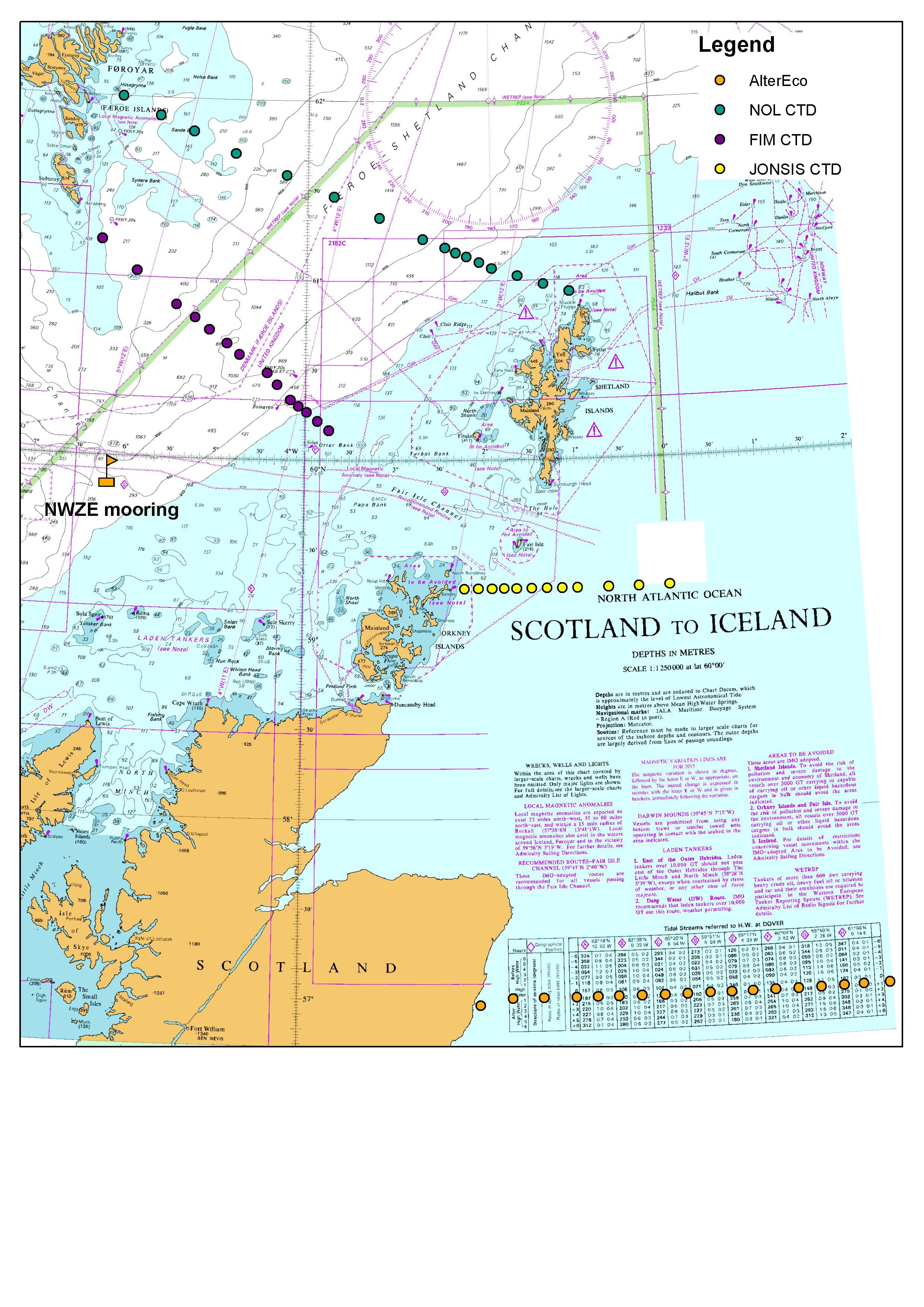
Table 1: JONSIS line
| CODES | # | Name | Latitude | Longitude | Depth | Spacing |
| N, T,O, CH, DS | 01 | JO 1 | 59° 17.00′ N | 02° 14.00′ W | 75 m | |
| N,CH
|
02 | JO 1A | 59° 17.00′ N | 02° 5.00′ W | 90 m | 4.59 nm |
| N,CH
|
03 | JO 2 | 59° 17.00′ N | 01° 56.00′ W | 100 m | 4.59 nm |
| N, T,O,CH, DS | 04 | JO 3 | 59° 17.00′ N | 01° 48.00′ W | 80 m | 4.08 nm |
| N,CH
|
05 | JO 4 | 59° 17.00′ N | 01° 40.00′ W | 90 m | 4.08 nm |
| N,CH
|
06 | JO 5 | 59° 17.00′ N | 01° 30.00′ W | 95 m | 5.10 nm |
| N,CH
|
07 | JO 6 | 59° 17.00′ N | 01° 20.00′ W | 110 m | 5.10 nm |
| N, T,O,CH, DS | 08 | JO 6A | 59° 17.00′ N | 01° 10.00′ W | 120 m | 5.10 nm |
| N,CH
|
09 | JO 7 | 59° 17.00′ N | 01° 0.00′ W | 125 m | 5.10 nm |
| N,CH
|
10 | JO 8 | 59° 17.00′ N | 00° 40.00′ W | 120 m | 10.20 nm |
| N,CH
|
11 | JO 9 | 59° 17.00′ N | 00° 20.00′ W | 140 m | 10.20 nm |
| N, T,O,
CH, DS |
12 | JO10 | 59° 17.00′ N | 00° 0.00′ W | 135 m | 10.20 nm |
| Totals | 1180 m | 68.36 nm | ||||
Priority Stations are JO-01, JO-03 and JO-06a, JO-10
Standard depths of water bottles:
5, 10, 20, 30, 50, 75, 100 and bottom*
*Fire a ‘bottom’ bottle if seabed is more than 20m below the lowest standard bottle
Table 2: Nolso-Flugga line
| CODES | # | Name | Latitude | Longitude | Depth | Spacing | ||||||||
| N, CH, DS
|
01 | NOL-01 | 60° 56.00′ N | 01° 00.00′ W | 110 m | |||||||||
| N, CH
ARIES |
02 | SEFN1 | 60° 58.70′ N | 01° 17.70′ W | 125 m | 9.00 nm | ||||||||
| N, CH | 03 | SEFN2 | 61° 01.40′ N | 01° 35.40′ W | 155 m | 8.99 nm | ||||||||
| N, T, O, CH | 04 | NOL-02 | 61° 04.00′ N | 01° 53.00′ W | 270 m | 8.91 nm | ||||||||
| N, CH, DS
ARIES |
05 | SEFN3 | 61° 06.00′ N | 02° 01.50′ W | 440 m | 4.57 nm | ||||||||
| N, CH | 06 | NOL-03 | 61° 08.00′ N | 02° 10.00′ W | 550 m | 4.57 nm | ||||||||
| N, CH | 07 | SEFN4 | 61° 09.30′ N | 02° 17.50′ W | 630 m | 3.85 nm | ||||||||
| N, CH | 08 | NOL-3a | 61° 11.00′ N | 02° 25.00′ W | 730 m | 3.98 nm | ||||||||
| N, T, O, CH, DS
ARIES |
09 | NOL-04 | 61° 14.00′ N | 02° 40.00′ W | 1080 m | 7.82 nm | ||||||||
| N, CH
ARIES (Priority) |
10 | NOL-05 | 61° 21.00′ N | 03° 10.00′ W | 1370 m | 16.03 nm | ||||||||
| N, T, O, CH
ARIES (Priority) |
11 | NOL-06 | 61° 28.00′ N | 03° 42.00′ W | 1235 m | 16.84 nm | ||||||||
| Nil | 12 | FARN2 | 61° 32.00′ N | 03° 57.00′ W | 1200 m | 8.18 nm | ||||||||
| N, CH, DS
ARIES |
13 | NOL-07 | 61° 35.00′ N | 04° 15.00′ W | 990 m | 9.08 nm | ||||||||
| Nil | 14 | FARN1 | 61° 38.00′ N | 04° 33.00′ W | 530 m | 9.07 nm | ||||||||
| N, T, O, CH
ARIES |
15 | NOL-08 | 61° 42.00′ N | 04° 51.00′ W | 235 m | 9.44 nm | ||||||||
| N, CH
|
16 | NOL-09 | 61° 49.00′ N | 05° 21.00′ W | 180 m | 15.84 nm | ||||||||
| N, CH, DS | 17 | NOL-10 | 61° 54.00′ N | 05° 45.00′ W | 290 m | 12.37 nm | ||||||||
| N, T, O,CH
|
18 | NOL-11 | 62° 00.00′ N | 06° 12.00′ W | 125 m | 14.04 nm | ||||||||
| Totals | 10245 m | 162.60 nm | ||||||||||||
Standard depths of water bottles:
5, 50, 100, 200, 300, 400, 500, 600, 700, 800, 900, 1000, 1100, 1200 and bottom
If all 12 bottles used drop 50m, 200m and 400m depths in this order.
Fire a bottom bottle if seabed is more than 50m below the lowest standard bottle
If stations need to be missed they should be dropped in this order
[Priority 4: FARN1, FARN2], [Priority 3: SEFN1, SEFN2, SEFN3, SEFN4]
[Priority 2, NOL-3a, NOL-05, NOL-07, NOL-10]
ARIES Priorities: drop SEFN1 and NOL8 first
Table 3: AlterEco line
Some stations coincide with the Aberdeen-Hanstholm standard section operated by the Norwegians and Germans; these are priority stations. The Stonehaven Monitoring Site does not need to be sampled if it was recently (<7 d) sampled as part of SCObs.
| CODE | # | Name | Latitude | Longitude | Depth | Spacing |
| N, CH | 01 | AlterEco1 | 57° 00.00′ N | 02° 04.00′ E | ||
| N, CH | 02 | AlterEco2 | 57° 00.00′ N | 01° 48.00′ E | 8.72 nm | |
| N, CH | 03 | AlterEco3 | 57° 00.00′ N | 01° 36.00′ E | 6.54 nm | |
| 04 | AlterEco4 | 57° 00.00′ N | 01° 22.00′ E | 7.63 nm | ||
| N, CH | 05 | AlterEco5 | 57° 00.00′ N | 01° 08.00′ E | 7.63 nm | |
| 06 | AlterEco6 | 57° 00.00′ N | 00° 54.00′ E | 7.61 nm | ||
| N, CH | 07 | AlterEco7 | 57° 00.00′ N | 00° 40.00′ E | 7.61 nm | |
| 08 | AlterEco8 | 57° 00.00′ N | 00° 27.00′ E | 7.09 nm | ||
| N, CH | 09 | AlterEco9 | 57° 00.00′ N | 00° 14.00′ E | 7.09 nm | |
| 10 | AlterEco10 | 57° 00.00′ N | 00° 00.00′ E | 7.61 nm | ||
| N, CH | 11 | AlterEco11 | 57° 00.00′ N | 00° 14.00′ W | 7.61 nm | |
| 12 | AlterEco12 | 57° 00.00′ N | 00° 28.00′ W | 7.63 nm | ||
| N, CH | 13 | AlterEco13 | 57° 00.00′ N | 00° 42.00′ W | 7.63 nm | |
| 14 | AlterEco14 | 57° 00.00′ N | 00° 55.00′ W | 7.07 nm | ||
| N, CH | 15 | AlterEco15 | 57° 00.00′ N | 01° 08.00′ W | 7.07 nm | |
| N, CH | 16 | AlterEco16 | 57° 00.00′ N | 01° 28.00′ W | 10.91 nm | |
| 17 | AlterEco17 | 57° 00.00′ N | 01° 47.00′ W | 10.56 nm | ||
| N, CH | 18 | AlterEco18 | 56° 57.80′ N | 02° 06.80′ W | 10.78 nm | |
| Totals | 136.83 nm | |||||
Priority Stations are AlterEco1, 2, 3, 5, 7, 9, 11, 13, 15, 16. AlterEco18 is a priority station if the SCObs sampling programme has not visited the site in the previous 7 days.
Standard depths of water bottles:
10, 30, 50, and bottom*
*Fire a ‘bottom’ bottle if seabed is more than 20m below the lowest standard bottle
Table 4: Fair Isle – Munken line
(Amended for presence of Foinaven oil platform)
| CODE | # | Name | Latitude | Longitude | Depth | Spacing |
| N, CH, DS | 01 | FIM-01 | 60° 10.00′ N | 03° 44.00′ W | 150 m | |
| N, CH | 02 | SEFF1 | 60° 13.00′ N | 03° 51.50′ W | 170 m | 4.74 nm |
| N, T, O, CH | 03 | FIM-02 | 60° 16.00′ N | 03° 59.00′ W | 200 m | 4.84 nm |
| N, CH
ARIES |
04 | SEFF2 | 60° 18.00′ N | 04° 04.50′ W | 330 m | 3.36 nm |
| N, CH, DS | * 05 | FIM-03 | 60° 20.00′ N | 04° 10.00′ W | 390 m | 3.03 nm |
| N, CH | 06 | FIM-04 | 60° 25.00′ N | 04° 19.00′ W | 655 m | 6.88 nm |
| N, CH
ARIES |
07 | FIM-05 | 60° 29.00′ N | 04° 26.00′ W | 995 m | 5.45 nm |
| N,T,O,CH
ARIES (Priority) |
08 | FIM-06 | 60° 35.00′ N | 04° 45.00′ W | 1090 m | 11.15 nm |
| N, CH, DS | 09 | FIM-6a | 60° 38.00′ N | 04° 54.00′ W | 1030 m | 5.33 nm |
| N, CH
ARIES |
10 | FIM-07 | 60° 43.00′ N | 05° 06.00′ W | 915 m | 7.70 nm |
| N, T, O, CH | 11 | FIM-08 | 60° 47.00′ N | 05° 16.00′ W | 830 m | 6.34 nm |
| N, CH, DS | 12 | FIM-09 | 60° 51.00′ N | 05° 29.00′ W | 600 m | 7.36 nm |
| Nil | 13 | FARF3 | 60° 56.70′ N | 05° 42.80′ W | 333 m | 8.90 nm |
| N, CH
ARIES |
14 | FIM-10 | 61° 02.00′ N | 05° 57.00′ W | 280 m | 8.68 nm |
| Nil | 15 | FARF2 | 61° 07.20′ N | 06° 09.40′ W | 250 m | 7.95 nm |
| N, T, O, CH, DS | 16 | FIM-11 | 61° 12.00′ N | 06° 22.00′ W | 240 m | 7.67 nm |
| Nil | 17 | FARF1 | 61° 16.40′ N | 06° 37.70′ W | 100 m | 8.80 nm |
| Totals | 8,558 m | 108.18 nm | ||||
* FIM-03 – Use 60 20.25’N 004 09.00’W if above position is occupied.
Standard depths of water bottles:
5, 50, 100, 200, 300, 400, 500, 600, 700, 800, 900, 1000 and bottom
If all 12 bottles used drop 50m depth. Fire a bottom bottle if seabed is more than 50m below the lowest standard bottle
If stations need to be missed they should be dropped in this order
[Priority 4: FARF1, FARF2. FARF3], [Priority 3: SEFF1, SEFF2], [Priority 2, FIM-04, FIM-06a, FIM-07]
ARIES Priorities: drop SEFF2 and FIM10 first (Highest priority in this order: FIM6, FIM7, FIM5)
Further Information:
- More Faroe-Shetland blogs
- Marine Scotland research vessels and surveys
- Other research vessel survey blogs
Tags: Faroe-Shetland Channel, plankton, sampling

Leave a comment