
Marine
Getting to the Bottom of things
January 23, 2018 by Marine Directorate Communications No Comments | Category Marine Directorate Science, Research Vessel Surveys, Uncategorized
Duration: 23 January – 12 February 2018
Fishing Gear:
- GOV Trawl (BT 137) with ground gear A & B
- MIK Net (Round Frame with IK depressor)
- MIKeyM net (attached onto the MIK net on selected stations)
Objectives:
- To complete an internationally coordinated demersal trawling survey in the North Sea in ICES area IV.
- To undertake MIK sampling for pre-metamorphosed herring larvae during the hours of darkness within the trawl survey area. MIKeyM samples will also be collected from the MIK deployments.
- To obtain temperature and salinity data from the surface and seabed at each trawling station using a SEABIRD 19+ CTD.
- Collect additional biological data in connection with the EU Data Collection Framework (DCF).
Trawling:
Hauls of 30 minutes duration will be made using the GOV trawl. Wherever possible, fishing will be carried out during daylight hours as defined below:
For each degree of longitude west, four minutes will be added to the time; for each degree of longitude east, four minutes will be subtracted.
The survey area is outlined in the attached chart (see Figure 1) but the exact fishing position will be decided in collaboration with the fishing master. The Scanmar system will be used throughout the survey to monitor headline height, wing spread, door spread and distance covered during each haul. A bottom contact sensor (BCS) will be attached to the ground-gear and the data collected will be downloaded after each haul.
Catches will be processed as per the most recent version of the IBTS sampling manual (ICES SISP 10 – IBTS IX) with additional biological data collected for species as determined.
MIK Sampling:
Pre-metamorphosed herring larvae will be sampled during the hours of darkness with the MIK mid-water trawl (Round frame). As standard a minimum of two double oblique tows will be made in every square within the assigned survey area. The vertical profile of the tow will be monitored using the Scanmar system. During this survey the small 20 mm round frame net (MIKeyM net) will also be deployed on all MIK stations for the purpose of collecting pelagic fish eggs from the survey area.
Hydrography:
Surface and bottom temperatures, salinities, nitrates, silicates and phosphates will be taken at all trawl stations.
Further Information:
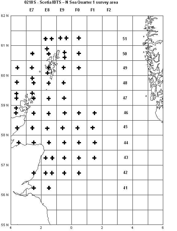
Figure 1: Scottish survey area for 0218S. Rectangles with two crosses will be trawled twice where possible.

Leave a comment