
Marine
Recover, Download, Re-deploy, Repeat
May 4, 2018 by Marine Directorate Communications No Comments | Category Marine Directorate general, Marine Directorate Science, Marine Directorate Surveys, Oceanography, Research Vessel Surveys
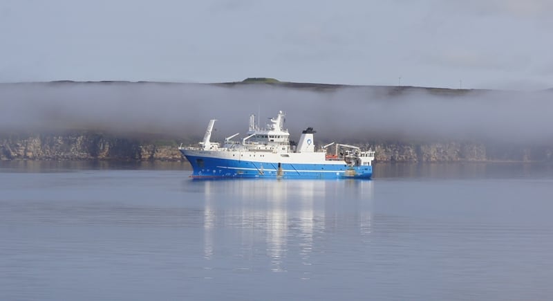
Survey: 0618S – MRV Scotia
Duration: 2-12 May 2018
Gear:
Sea-Bird CTDs, ADCPs and current meter instrumentation, water filtering equipment, mooring equipment, chemistry sampling and analysis equipment.
Objectives:
- Perform hydrographic sampling along the AlterEco monitoring section in the northern North Sea, which will be sampled on all MSS oceanographic surveys in 2018.
- Perform hydrographic sampling along the JONSIS long term monitoring section in the northern North Sea.
- Recover, download and re-deploy an ADCP mooring deployed in a trawl-proof frame on the JONSIS section (the “AlterEco mooring”, AECO).
- Recover and download the data from one ADCP mooring deployed on Faroe-Shetland Channel Faroe – Cape Wrath (FCW/NWZ) section, in the vicinity of the Wyville-Thomson Ridge (NWZE).
- Recover, download and re-deploy one ADCP mooring at a position on Fair Isle – Munken (FIM/NWS) section
- Take surface water samples at a suitable location in the Faroe Shetland Channel for bacterial analysis and experimentation (HWU).
- Perform hydrographic sampling along the long term monitoring Faroe-Shetland Channel Nolso – Flugga (NOL/NWE) section.
- Recover, download and re-deploy two ADCP moorings at positions on Faroe-Shetland Channel Nolso – Flugga section.
- Take water samples for long term storage on Fair Isle – Munken or Nolso – Flugga section stations.
- Perform hydrographic sampling along the long term monitoring Faroe-Shetland Channel Fair Isle – Munken (FIM/NWS) section.
- Run the thermosalinograph throughout the survey.
- Perform hydrographic sampling in the vicinity of a number of ADCP moorings in order to calibrate moored equipment: CTD dips at selected locations with equipment (SB56 NanoCAT and/or SB57 MicroCAT) attached to carousel.
- If sheltering in a suitable location around Shetland due to bad weather, conduct VMADCP/CTD work in Shetland (e.g. Yell Sound) and short-term mooring deployment and recovery.
- If weather/time permits, perform fine scale VMADCP/CTD survey work on the JONSIS line (around 59° 16.96′ N, 001° 15.26′ W).
- If weather/time permits, perform VMADCP/CTD survey work in the Moray Firth and/or Aberdeen Bay.
Procedure:
On sailing from Aberdeen Scotia will make passage to the start (western end) of the AlterEco monitoring section to carry out sampling with the CTD and carousel water sampler along the section. On completion, Scotia will head to the JONSIS section to carry out sampling with the CTD and carousel water sampler. Either prior to that work or during it, an ADCP mooring deployed on JONSIS in an AL200 trawl-proof frame (AECO) will be recovered, downloaded and re-deployed.
Passage will then be made towards the NWZE mooring location near the Wyville-Thomson Ridge to recover and download an ADCP mooring, performing a calibration dip at a suitable location once the instruments have been recovered. Subsequent to the recovery of mooring NWZE, Scotia will recover an ADCP mooring on the Fair Isle – Munken (FIM) section (NWSE). Data will be downloaded and the mooring will then be re-deployed. Surface water will be collected at a suitable station nearby for bacterial work by the HWU visitor.
Scotia will then make her way to the eastern start location for the Nolso – Flugga (NOL) section and, depending on timings, either recover one ADCP mooring (NWEZ) along the way or start collecting long term monitoring samples and taking CTD profiles from the start of the section. At two relevant locations along NOL (NWEZ, NWEA), mooring recovery and re-deployments will be carried out, with calibration CTD dips for instruments recovered from some of the moorings. After the NOL section, Scotia will head to the western (Faroe) side of the FIM section to carry out standard CTD and water sampling along that line.
Once that work is completed and if time allows, Scotia will carry out additional work (listed among the survey objectives) along the JONSIS line, in the Moray Firth and/or Aberdeen Bay, prior to her return to Aberdeen. If the weather requires sheltering in Shetland and any point during the survey, we will aim to collect additional CTD and VMADCP data in suitable locations (e.g. Yell Sound) and, if time and conditions allow, deploy and recover short-term (> 13 h) current meter moorings (Seaguard current meters).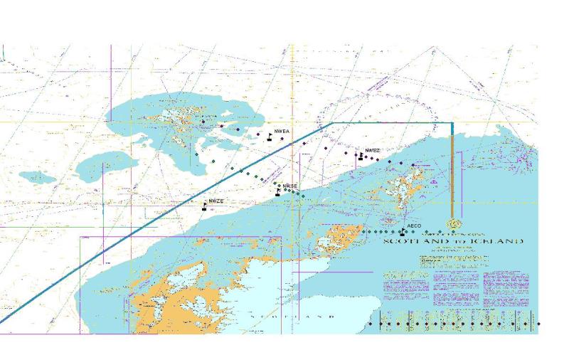
Mooring Positions (Recovery):
- AECO – 59° 16.96′ N 001° 15.26′ W
- NWZE – 59° 54.56’ N 006° 10.14’ W
- NWEA – 61° 38.01’N 004° 32.60’W
- NWEZ – 61° 09.32′ N 002° 17.39′ W
- NWSE – 60° 16.34′ N 004° 20.67′ W
Mooring Positions (Deployment):
- AECO – 59° 17.00′ N 001° 15.00′ W on JONSIS
- NWEA – 61° 38.00 N 004° 33.00 W on NOL
- NWEZ – 61° 9.30 N 002° 17.52 W on NOL
- NWSE – 60° 16.29′ N 004° 20.78′ W on FIM
Scientific Procedures:
It is expected that deployments of hydrographic equipment will be carried out with the CTD crane whilst the vessel is on station. The plankton crane will be used for the deployment of ADCP moorings in trawl-proof frames (AL200 and AL500). Single-string ADCP mooring deployments will be done from the trawl deck.
Three container laboratories will be required (one wet chemical analysis laboratory, one for water filtering and a dry container for communications with sampling equipment). Chlorophyll samples will be stored frozen in the freezer in the Fish House.
Further Information:
Tags: Aberdeen Bay, AlterEco, Faroe-Shetland, JONSIS, Monitoring, moorings, Moray Firth, MRV Scotia, oceanographic, oceanography, sampling, Scotia

Leave a comment