
Marine
Pinging for Lost Moorings
December 10, 2018 by Marine Directorate Communications No Comments | Category Marine Directorate general, Marine Directorate Science, Marine Directorate Surveys, Oceanography, Research Vessel Surveys
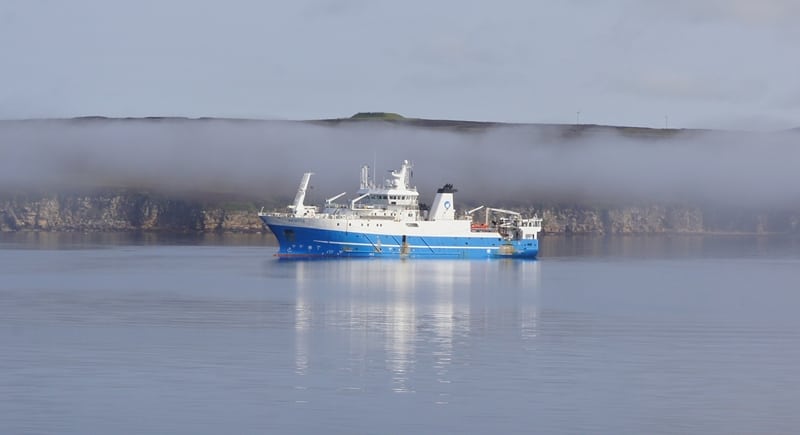
Survey: 1818S MRV Scotia
Duration: 8-18 December 2018
Gear:
- Sea-Bird Conductivity, Temperature, Depth (CTD) Unit/Carousel,
- Water filtering equipment,
- Mooring recovery equipment,
- Chemistry sampling equipment, and
- AL-200 Trawl-Resistant Bottom Mounts (TRBMs).
Objectives:
- Hydrographic sampling along the Stonehaven AlterEco section in the northern North Sea (Priority 1).
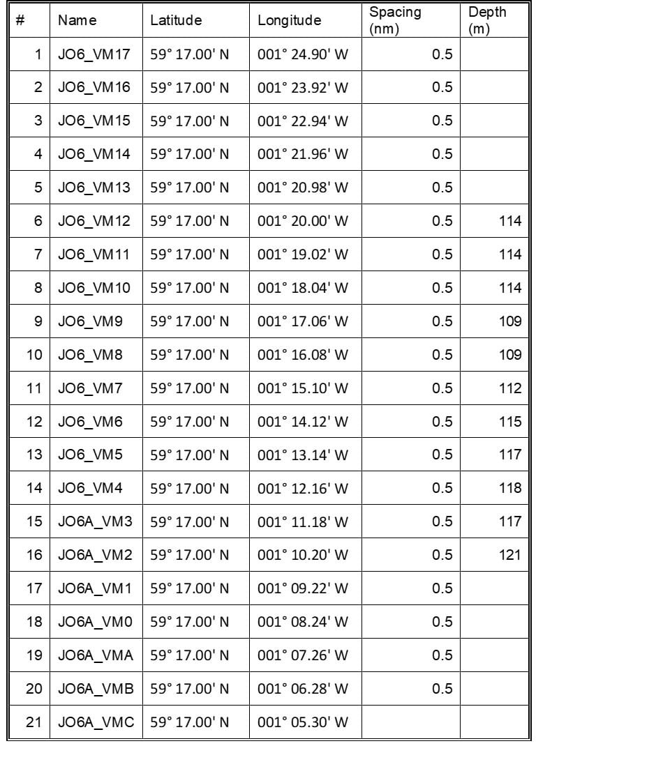
- Conduct routine hydrographic sampling at stations along the long-term monitoring Jonsis section in the northern North Sea (Priority 1).
- Use deck unit to ping for lost AECO AL-200 mooring on Jonsis line and attempt recovery if it is communicating (Priority 2).
- Perform routine hydrographic sampling at stations along the long-term monitoring Faroe-Shetland Channel section: Nolso-Flugga (Priority 1).
- Use deck unit to ping for lost NWEA AL-500 mooring on Nolso-Flugga (NOL) line and attempt recovery if it is communicating (Priority 2).
- Perform routine hydrographic sampling at stations along the long-term monitoring Faroe-Shetland Channel section Fair Isle-Munken (FIM) (Priority 2).
- Take salinity, nutrient, chlorophyll, Total Alkalinity/Dissolved Inorganic Carbon, dissolved oxygen samples along all standard lines.
- Should weather/time permit, perform a CTD or Vessel Mounted Acoustic Doppler Current Profiler (VMADCP) survey on part of the Jonsis line (around 59° 17.00′ N, 001° 15.26′ W) (Priority 3).
- If conditions in the Faroe-Shetland Channel don’t allow further work in the Faroe-Shetland Channel, conduct VMADCP/CTD work in the Moray Firth (Priority 3).
- Deploy a trawl resistant bottom frame (AL-200) containing an ADCP in the Moray Firth (9 nm off Wick).
- If sheltering in a suitable location around Shetland or Orkney due to bad weather conduct VMADP/CTD surveys.
- Run the thermosalinograph throughout the survey.
- Run the VMADCP on all the standard sections.
General Procedure:
After departing Aberdeen and completing appropriate drills, Scotia will make passage to the start (western end) of the AlterEco monitoring section to carry out sampling with the CTD and carousel water sampler along the section (Table 1, Figure 1).
On completion of that section, Scotia will head to the eastern end of the Jonsis section to carry out sampling with the CTD and carousel water sampler (Table 2, Figure 1). We will interrogate the lost mooring (AECO) on Jonsis and attempt recovery if the acoustic release is communicating.
The vessel will then proceed to the Faroe-Shetland Channel. We will commence hydrographic sampling along the NOL survey line (Table 3, Figure 1). We will interrogate the lost mooring (NWEA) on NOL and attempt recovery if the acoustic release is communicating.
On completion of the NOL line, if time allows, the vessel will proceed to conduct hydrographic sampling on the Fair Isle-Munken survey line (Table 4, Figure 1).
If we are sheltering in a suitable location around Shetland or Orkney we will run the VMADCP and perform CTD sampling along specified lines.
Deploy the Moray Firth AL-200 mooring when conditions allow. Once the priority 1 and 2 work is completed and if time allows, Scotia will carry out additional work (listed among the cruise objectives as priority 3) along the Jonsis line (Table 5) and/or in the Moray Firth, prior to her return to Aberdeen.
Mooring Positions (Pinging/Recovery):
Jonsis: AECO – AL-200: 59° 16.928′ N 001° 15.393′ W
Trawl resistant AL200 frame, (previously lost, attempt to communicate again)
NOL: NWEA – AL-500: 61° 38.01’N 004° 32.60’W
AL-500 frame, (previously lost, attempt to communicate again)
Mooring Position (Deployment):
Moray Firth: AL-200: 58° 18.5’ N, 002° 58.5’ W
Scientific Procedures:
It is expected that deployments of hydrographic equipment will be carried out with the CTD crane whilst the vessel is on station. The plankton crane will be used for the deployment of the ADCP mooring in trawl-resistant frame (AL200).
Three container laboratories will be required (one wet chemical analysis laboratory, two dry containers for electronics work and communications with sampling equipment).
Chlorophyll samples will be stored frozen in the freezer in the Fish House.
The thermosalinograph will be run throughout the survey.
Figure 1: Map including the main monitoring lines AlterEco, Jonsis, NOL, and FIM, and the mooring locations.
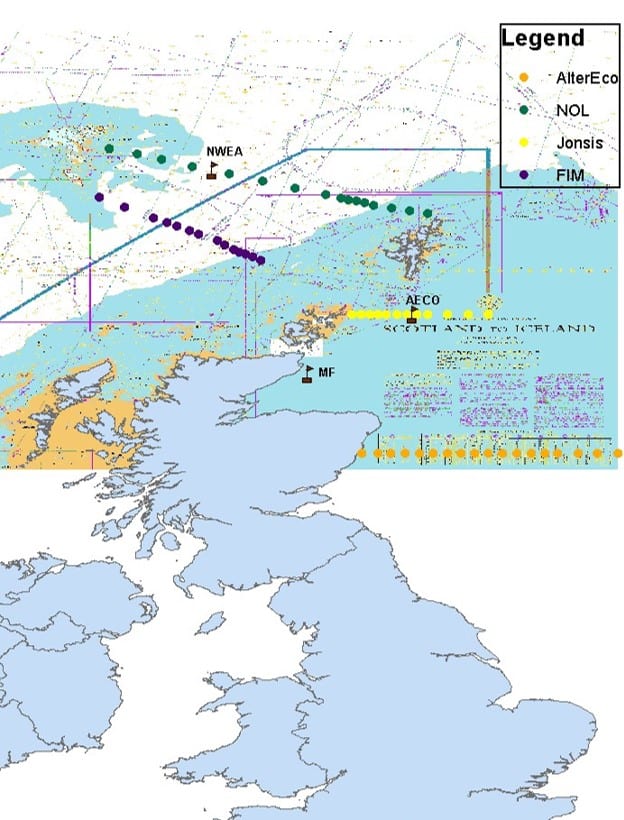
Table 1: ALTERECO line
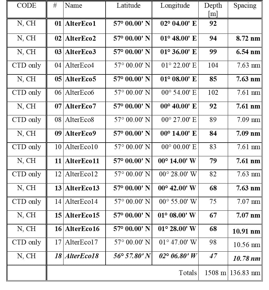
Table 2: Jonsis line

Table 3: Nolso-Flugga
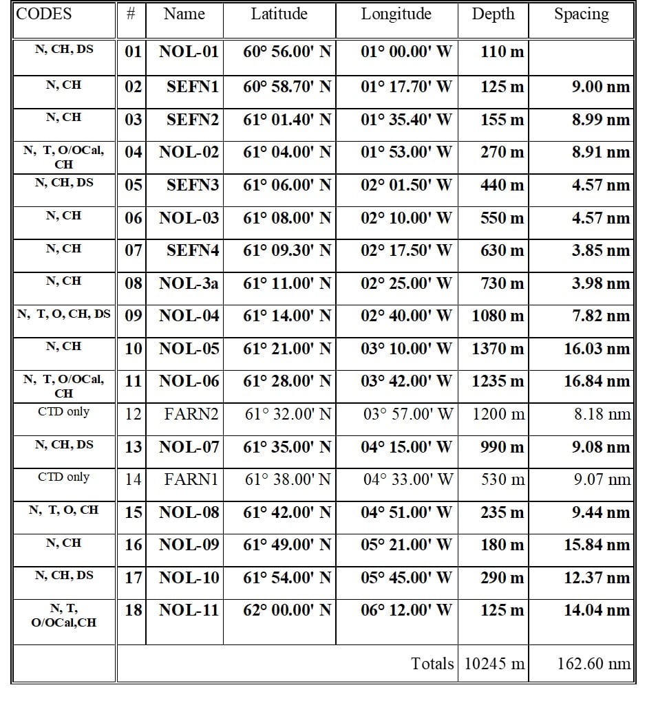
Table 4: Fair Isle – Munken
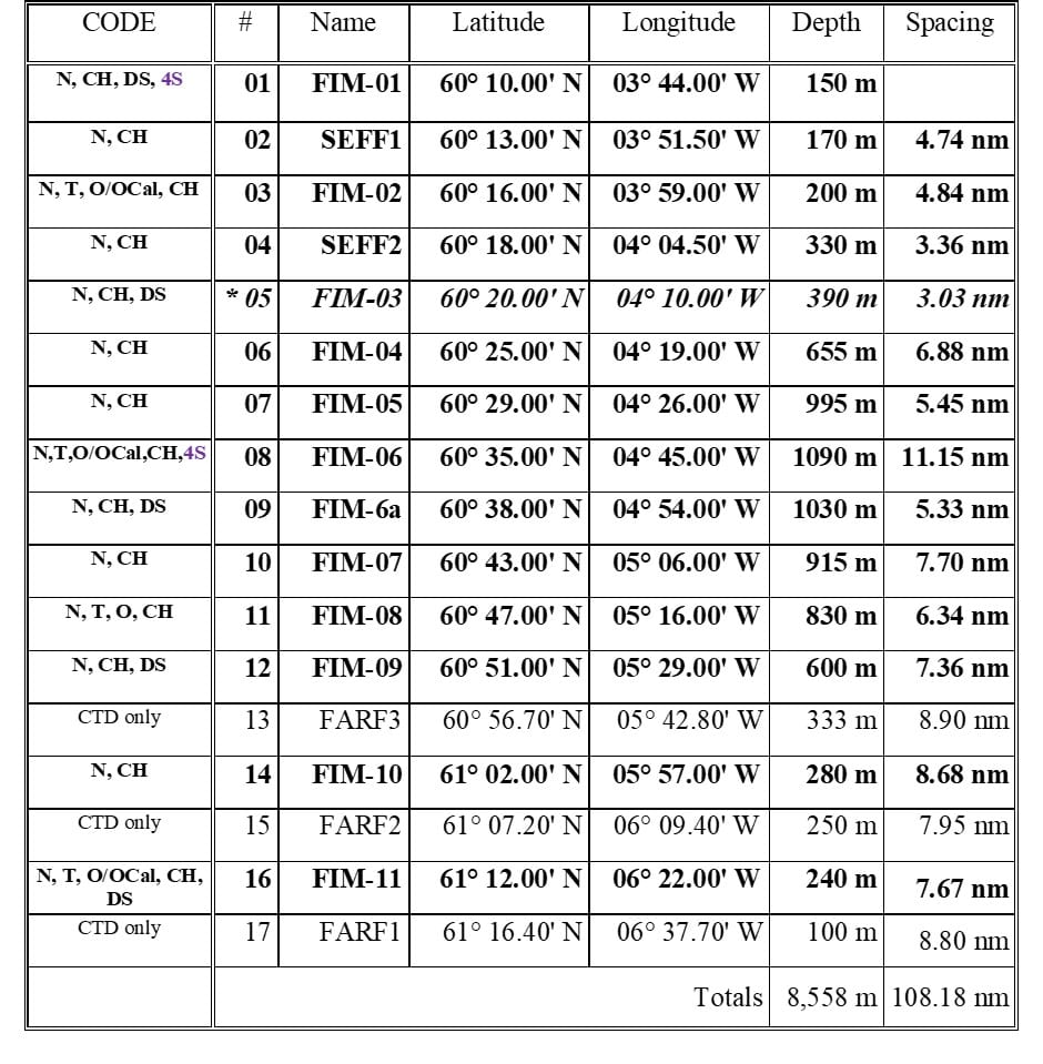
Table 5: Extra Jonsis work
Further Information:
Tags: acoustic moorings, AlterEco, Faroe-Shetland Channel, hydrographic sampling, JONSIS, Moray Firth, MRV Scotia, North Sea, Orkney, sampling, science, Scotia, Shetland, Survey, water sampling

Leave a comment