
Marine
Hydrographic Sampling at Sea
December 13, 2019 by Marine Directorate Communications No Comments | Category Marine Directorate general, Marine Directorate Science, Marine Directorate Surveys, Research Vessel Surveys
MRV Scotia
Survey: 1919S Programme
Duration: 12-22 December 2019
Gear: Sea-Bird CTD/Carousel, water filtering equipment, mooring deployment/recovery equipment, chemistry sampling equipment.
Objectives:
- Test the SBE911 and CTD carousel (main CTD crane) and the SBE25 and Aquatracka (using plankton crane) in the Buchan Deep.
- Perform routine hydrographic sampling at stations along the long term monitoring JONSIS section in the northern North Sea (Priority 1).
- Perform routine hydrographic sampling at stations along the long term monitoring Faroe-Shetland Channel section: Nolso-Flugga (Priority 1).
- Perform routine hydrographic sampling at stations along the long term monitoring Faroe-Shetland Channel section Fair Isle-Munken (Priority 1).
- Take salinity, nutrient, chlorophyll, dissolved oxygen samples along all standard lines.
- Run the thermosalinograph throughout the survey.
- Run the VMADCP on all the standard sections.
Extra work listed below will be performed if time allows, the order of Priority 2 pieces of work are not listed in order of importance and the sequence will be determined depending on time/location/weather: - Opportunistically communicate with lost ADCP mooring on NOL section and Foinaven mooring and potentially recover (Priority 2).
- Deploy one new ADCP (NWEX) on a single string mooring on the NOL section (Priority 2).
- If weather/time permits repeat the JONSIS line at the end of the survey and extend to 001° 30’ east (if we have Norwegian clearance) (Priority 2).
- Perform hydrographic sampling along the Shelf 1 section (NW of Orkney) (Priority 2).
- Perform hydrographic sampling along the Shelf 2 section (NW of Orkney) (Priority 2).
- Perform hydrographic sampling along the Shelf 3 section (NW of Orkney) (Priority 2).
- Perform hydrographic sampling along the East Coast section (in the Northern North Sea) (Priority 2).
- Perform hydrographic sampling along the Fedje/Shetland section between Shetland and Norway (in the Northern North Sea, if we have Norwegian clearance) (Priority 2).
- Perform hydrographic sampling along the Stonehaven AlterEco section in the northern North Sea (Priority 2).
- If conditions in the Faroe-Shetland Channel don’t allow further work in the Faroe-Shetland Channel, conduct VMADCP/CTD work in the Moray Firth (details to be determined) (Priority 3).
- If weather/time permits, perform a CTD/VMADCP survey on part of the Jonsis line (around 59° 17′ N, 001° 15′ W) (Priority 3).
- If sheltering in a suitable location around Shetland or Orkney due to bad weather conduct VMADP/CTD surveys (details to be determined). (Priority 3).
General Procedure:
After departing Aberdeen and completing appropriate drills, Scotia will make passage to Buchan Deep for a test dip. On completion, Scotia will head to the eastern end of the JONSIS section to carry out sampling with the CTD and carousel water sampler (Table 1, Figure 1). The vessel will then proceed to the Faroe-Shetland Channel. We will commence hydrographic sampling along the Nolso Flugga survey line (Table 2, Figure 1). On completion of the Nolso Flugga line, the vessel will proceed to conduct hydrographic sampling on the Fair Isle-Munken survey line (Table 3, Figure 1).
Once the Priority 1 work is completed (or if time allows during priority one work) and if time allows, Scotia will carry out additional work (listed among the survey objectives as Priority 2 and 3, Figure 2). This extra work will include the interrogation of the lost moorings, and attempt recovery if the acoustic release is communicating; the deployment of mooring NWEX on NOL; extra hydrographic lines on the shelf and/or the North Sea. In case we are sheltering in a suitable location around Shetland, Orkney or the Moray Firth we will run the VMADCP and perform CTD sampling along specified lines (to be determined).
Mooring Positions (Pinging/Recovery)
NWSE 60° 16.29′ N 004° 20.76′ W Short single string mooring (lost)
NWEA 61° 38.01′ N 004° 32.60′ W (lost)
Mooring Position (Deployment)
NWEX 61° 11.00’ N 002° 25.00’ W Single string mooring
Scientific Procedures:
It is expected that deployments of hydrographic equipment will be carried out with the CTD crane whilst the vessel is on station. Single-string ADCP mooring deployment will be done from the trawl deck.
Two container laboratories will be required (one for water filtering and a dry container for communications with sampling equipment). Chlorophyll samples will be stored frozen in the freezer in the Fish House and nutrient samples will be stored in fish-free freezer down below.
The thermosalinograph will be run throughout the survey.
(NOTE: The survey will potentially take Scotia into the Foinaven Development Area. This is now standard practice, and normal on-site communications will be established with the Foinaven co-ordinating officer).
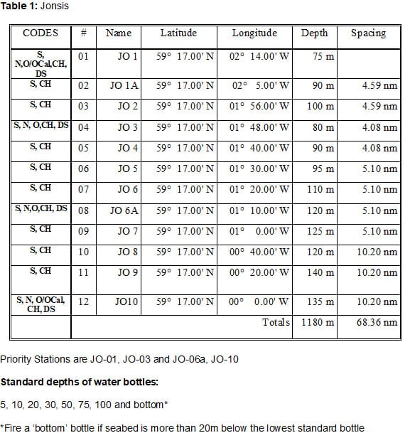
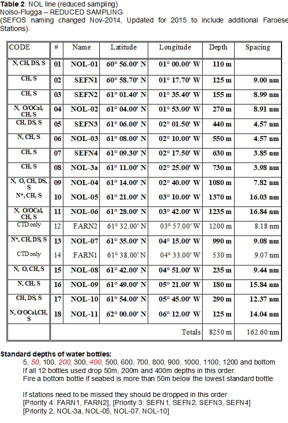
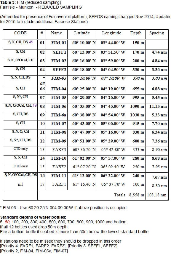
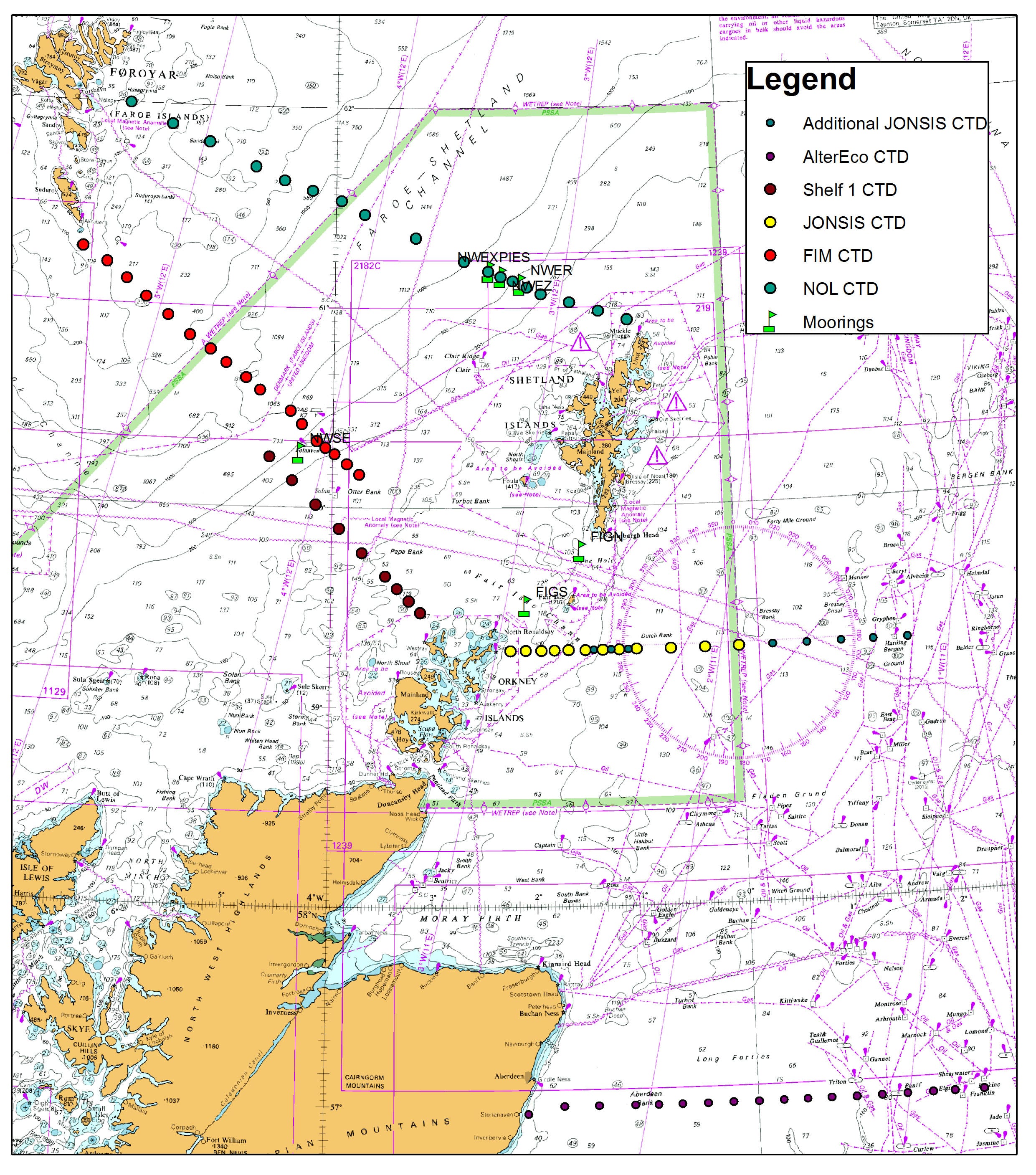
Figure 1: Map of main monitoring lines (Jonsis, NOL, FIM) (including some of the extra lines, no indication of their importance).
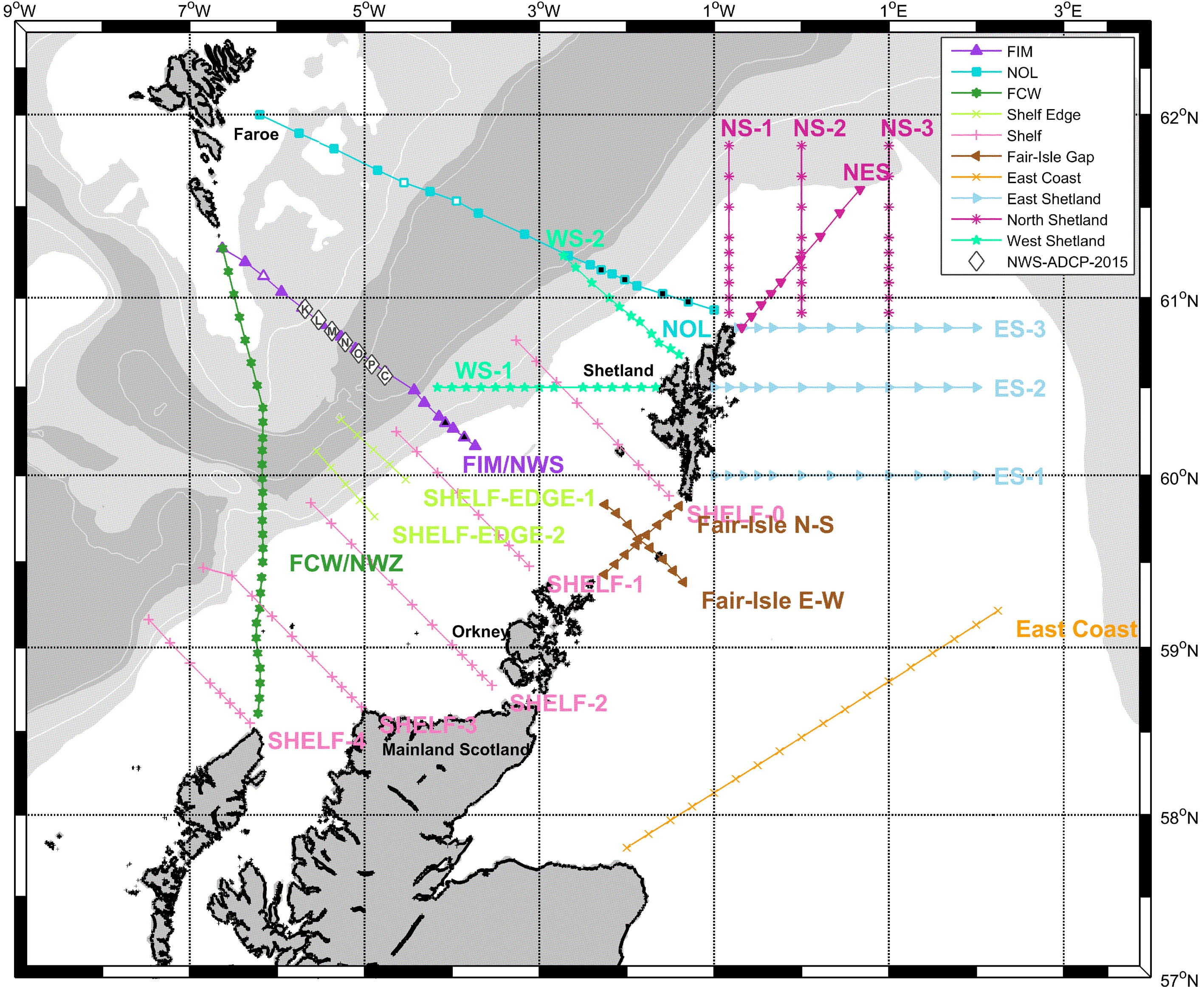
Figure 2. Map of some of the extra hydrographic lines (details to be provided at a later stage when necessary).
Further Information:
Tags: Buchan Deep, Faroe-Shetland Channel, hydrographic sampling, JONSIS, northern North Sea, thermosalinograph

Leave a comment