
Marine
Clean Seas Environmental Monitoring Programme
January 8, 2020 by Marine Directorate Communications No Comments | Category Marine Directorate general, Marine Directorate Science, Research Vessel Surveys
MRV Scotia Programme
Survey: 0120S
Duration: 6-21 January 2020
Fishing gear: BT 137 with Ground gear E;
Sediment Sampling: Day grab
Litter sampling: Catamaran and neuston trawl
Water sampling: Aquatracka fluorometer, Seabird 25 and modified acoustic sledge
Objectives:
- To undertake water, sediment and biological sampling for the Clean Seas Environmental Monitoring Programme (CSEMP).
- Monitor and record all litter brought aboard in all trawls. Sample water column and sediment for micro-plastic litter. Collect fish guts and any other biota of interest for microplastic research.
- If possible, deploy Aquatracka and Seabird 25 to collect fluorescence data.
Procedure:
Scientific staff will join the vessel on 05 January 2020 to conduct final set-up of scientific equipment. After required drills, the vessel will depart Leith (am) on 06 January and head for the nearest sampling station as agreed with the master and fishing master. The order in which sampling stations will be undertaken will be agreed on a daily basis and in line with current weather conditions.
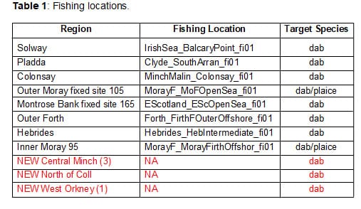
Fish sampling for biological effect assessment will be carried out at multiple locations detailed in Table 1.
Due to a lack of sites in certain sampling regions, new sites (in red in Table 1) will be tested and assessed for the collection of dab (in Central Minch, North of Coll and West of Orkney). If successful, the target species will be sampled for biological effect assessment and chemistry analysis.
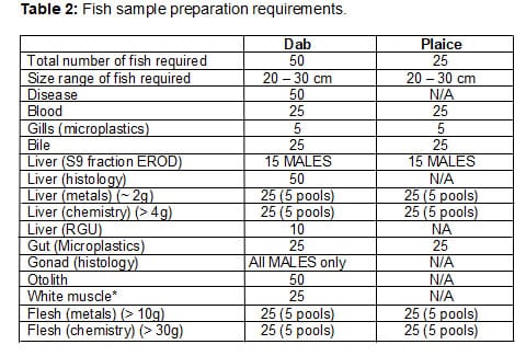
 Fish will be sampled for chemical analyses, biological effects and fish diseases (Table 2). Some biological effects measurements will be carried out during the survey.
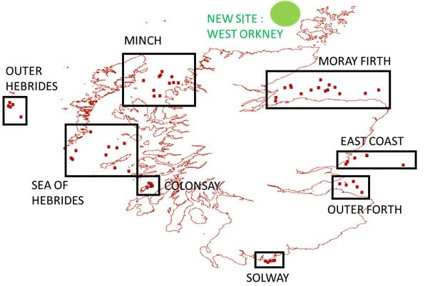
 Sediment sampling will be carried out at the Montrose bank, East coast, Inner and Outer Moray Firth, Minch North, Minch South, Colonsay, Outer Hebrides, Sea of Hebrides and Solway sites. Sediment sampling will also be carried out at the four CSEMP fixed sites (NMMP85 – North Minch, NMMP95 – Inner Moray Firth, NMMP105 – Outer Moray Firth, NMMP165 – Montrose Bank) (see Map 1). Sediments will be sampled for chemical analyses at all locations. The coordinates of all sediments site is shown in Table 3 (Primary sites) and Table 4 (Secondary sites – used if Sampling a Primary site failed).
Sediment sampling will also be attempted in the West of Orkney (exact location to be confirmed – see green circle on (Map 1) to add another sampling site on the CSEMP programme.
Monitoring of all litter brought on board during trawling operations will continue throughout the survey. The catamaran will be deployed to sample for micro-plastics whenever possible (exact high priority locations to be confirmed) and samples processed onboard as far as possible. Additional sediment samples will also be taken for micro-plastics where possible. Fish guts and any other biota of interest might also be preserved and returned to the lab for analysis (exact sampling requirements to be confirmed)
The Aquatracka will be deployed in the Forth and in at least one other area to obtain reference measurements. Vertical profiling will be performed and tows using the modified acoustic sledge will also be tested.
Table 3: Sediment grabs locations – PRIMARY SITES.
| REGION | Field ID | decLat | decLong | Latitude | Longitude |
| Outer Forth | E of Isle of May | 56.1994 | -2.4096 | 56 11.96N | 002 24.57W |
| N of Wheat Stack | 55.9998 | -2.2497 | 55 59.99N | 002 14.98W | |
| NE Torness | 56.1001 | -2.3404 | 56 6.00N | 002 20.42W | |
| Rath Grounds | 56.1593 | -2.6593 | 56 9.56N | 002 39.56W | |
| S of Isle of May | 56.1335 | -2.5351 | 56 8.01N | 002 32.11W | |
| The Minch North | UM1.1 | 58.0350 | -6.2100 | 58 2.10N | 006 12.60W |
| UM1.2 | 58.1060 | -5.6950 | 58 6.36N | 005 41.70W | |
| UM1.3 | 57.9870 | -5.7430 | 57 59.22N | 005 44.58W | |
| UM1.4 | 58.2000 | -5.8800 | 58 12.00N | 005 52.80W | |
| UM1.5 | 57.9910 | -5.5810 | 57 59.46N | 005 34.86W | |
| 85se | 58.0000 | -5.6667 | 58 0.00N | 005 40.00W | |
| The Minch South | UM2.1 | 58.1120 | -5.9310 | 58 6.72N | 005 55.86W |
| UM2.2 | 58.1320 | -5.8980 | 58 7.92N | 005 53.88W | |
| UM2.3 | 57.8590 | -6.0280 | 57 51.54N | 006 1.68W | |
| UM2.4 | 57.7540 | -6.0200 | 57 45.24N | 006 1.20W | |
| UM2.5 | 57.7580 | -5.9130 | 57 45.48N | 005 54.78W | |
| Sea of Hebrides | SOH1.1 | 56.7640 | -7.4390 | 56 45.84N | 007 26.34W |
| SOH1.2 | 56.6000 | -7.4990 | 56 36.00N | 007 29.94W | |
| SOH1.3 | 56.8310 | -6.8440 | 56 49.86N | 006 50.64W | |
| SOH1.4 | 56.4460 | -6.7310 | 56 26.76N | 006 43.86W | |
| SOH1.5 | 56.6270 | -7.5260 | 56 37.62N | 007 31.56W | |
| SOH1.6 | 56.6850 | -6.8890 | 56 41.10N | 006 53.34W | |
| SOH1.7 | 57.1010 | -7.1720 | 57 6.06N | 007 10.32W | |
| SOH1.8 | 56.8930 | -6.5550 | 56 53.58N | 006 33.30W | |
| SOH1.9 | 56.3870 | -6.4770 | 56 23.22N | 006 28.62W | |
| SOH1.10 | 56.8100 | -6.6940 | 56 48.60N | 006 41.64W | |
| Hebrides | HEB1 1 | 57.5560 | -8.6250 | 57 33.36N | 008 37.50W |
| HEB1 2 | 57.6370 | -8.6370 | 57 38.22N | 008 38.22W | |
| HEB1 3 | 57.5770 | -8.6640 | 57 34.62N | 008 39.84W | |
| HEB1 4 | 57.3750 | -8.4330 | 57 22.50N | 008 25.98W | |
| HEB1 5 | 57.6000 | -8.5810 | 57 36.00N | 008 34.86W | |
| Colonsay | COL1 | 56.1100 | -6.0800 | 56 6.60N | 006 4.80W |
| COL2 | 56.0890 | -6.1420 | 56 5.34N | 006 8.52W | |
| COL3 | 56.1180 | -6.0510 | 56 7.08N | 006 3.06W | |
| COL4 | 56.1520 | -6.0720 | 56 9.12N | 006 4.32W | |
| COL5 | 56.1680 | -6.1160 | 56 10.08N | 006 6.96W | |
| Solway | SOL1 | 54.7500 | -4.0000 | 54 45.00N | 003 60.00W |
| SOL2 | 54.7665 | -3.8345 | 54 45.99N | 003 50.07W | |
| SOL3 | 54.7565 | -3.8630 | 54 45.39N | 003 51.78W | |
| SOL4 | 54.7500 | -3.9157 | 54 45.00N | 003 54.94W | |
| SOL5 | 54.7272 | -3.9600 | 54 43.63N | 003 57.60W | |
| East Coast | EC1.1 | 56.5570 | -2.5100 | 56 33.42N | 002 30.60W |
| EC1.2 | 56.6690 | -2.1630 | 56 40.14N | 002 9.78W | |
| EC1.3 | 56.6270 | -2.3810 | 56 37.62N | 002 22.86W | |
| EC1.4 | 56.5180 | -2.5460 | 56 31.08N | 002 32.76W | |
| EC1.5 | 56.6780 | -2.1690 | 56 40.68N | 002 10.14W | |
| 165se | 56.5000 | -1.5000 | 56 30.00N | 001 30.00W | |
| Moray Firth | MF1.1 | 57.7320 | -3.8110 | 57 43.92N | 003 48.66W |
| MF1.2 | 57.9040 | -3.6480 | 57 54.24N | 003 38.88W | |
| MF1.3 | 57.7990 | -3.3580 | 57 47.94N | 003 21.48W | |
| MF1.4 | 57.9440 | -3.5460 | 57 56.64N | 003 32.76W | |
| MF1.5 | 57.9120 | -3.5300 | 57 54.72N | 003 31.80W | |
| MF2.1 | 57.9600 | -2.8450 | 57 57.60N | 002 50.70W | |
| MF2.2 | 57.9150 | -2.7380 | 57 54.90N | 002 44.28W | |
| MF2.3 | 57.8670 | -1.9490 | 57 52.02N | 001 56.94W | |
| MF2.4 | 57.8690 | -2.8690 | 57 52.14N | 002 52.14W | |
| MF2.5 | 57.8040 | -2.1900 | 57 48.24N | 002 11.40W | |
| MF2.6 | 57.7990 | -2.6530 | 57 47.94N | 002 39.18W | |
| MF2.7 | 57.8610 | -3.1720 | 57 51.66N | 003 10.32W | |
| MF2.8 | 57.8440 | -2.9130 | 57 50.64N | 002 54.78W | |
| MF2.9 | 57.9050 | -3.0410 | 57 54.30N | 003 2.46W | |
| MF2.10 | 57.9050 | -3.0410 | 57 54.30N | 003 2.46W | |
| 105se | 58.0500 | -3.0000 | 58 3.00N | 002 60.00W | |
| 95se | 57.6667 | -3.8167 | 57 40.00N | 003 49.00W |
Table 4: Sediment grabs locations – SECONDARY SITES
| REGION | Field ID | decLat | decLong | Latitude | Longitude |
| The Minch North | UM1.6 | 58.1330 | -5.6540 | 58 7.98N | 005 39.24W |
| UM1.7 | 58.3080 | -6.0300 | 58 18.48N | 006 1.80W | |
| UM1.8 | 58.1130 | -6.1690 | 58 6.78N | 006 10.14W | |
| UM1.9 | 58.2560 | -5.5300 | 58 15.36N | 005 31.80W | |
| UM1.10 | 58.2060 | -5.4990 | 58 12.36N | 005 29.94W | |
| The Minch South | UM2.6 | 57.8770 | -6.1830 | 57 52.62N | 006 10.98W |
| UM2.7 | 57.8420 | -6.1730 | 57 50.52N | 006 10.38W | |
| UM2.8 | 57.9390 | -6.0410 | 57 56.34N | 006 2.46W | |
| UM2.9 | 57.7180 | -6.1330 | 57 43.08N | 006 7.98W | |
| UM2.10 | 57.8310 | -5.9900 | 57 49.86N | 005 59.40W | |
| Sea of Hebrides | SOH1.11 | 56.8430 | -6.6550 | 56 50.58N | 006 39.30W |
| SOH1.12 | 56.7570 | -7.1110 | 56 45.42N | 007 6.66W | |
| SOH1.13 | 56.9120 | -7.2950 | 56 54.72N | 007 17.70W | |
| SOH1.14 | 56.7490 | -6.9390 | 56 44.94N | 006 56.34W | |
| SOH1.15 | 56.4480 | -7.1510 | 56 26.88N | 007 9.06W | |
| Hebrides | HEB1 6 | 57.6050 | -8.7390 | 57 36.30N | 008 44.34W |
| HEB1 7 | 57.6050 | -8.6920 | 57 36.30N | 008 41.52W | |
| HEB1 8 | 57.5150 | -8.6540 | 57 30.90N | 008 39.24W | |
| HEB1 9 | 57.4880 | -8.6440 | 57 29.28N | 008 38.64W | |
| HEB1 10 | 57.5790 | -8.7550 | 57 34.74N | 008 45.30W | |
| East Coast | EC1 6 | 56.7190 | -2.2080 | 56 43.14N | 002 12.48W |
| EC1 7 | 56.6350 | -2.3540 | 56 38.10N | 002 21.24W | |
| EC1 8 | 56.5450 | -2.4050 | 56 32.70N | 002 24.30W | |
| EC1 9 | 56.5540 | -2.4220 | 56 33.24N | 002 25.32W | |
| EC1 10 | 56.6490 | -2.2520 | 56 38.94N | 002 15.12W | |
| Moray Firth | MF1 6 | 57.9010 | -3.4510 | 57 54.06N | 003 27.06W |
| MF1 7 | 57.8740 | -3.6280 | 57 52.44N | 003 37.68W | |
| MF1 8 | 57.6440 | -3.6640 | 57 38.64N | 003 39.84W | |
| MF1 9 | 57.7200 | -3.6250 | 57 43.20N | 003 37.50W | |
| MF1 10 | 57.9200 | -3.6600 | 57 55.20N | 003 39.60W | |
| MF2 11 | 57.7750 | -2.3650 | 57 46.50N | 002 21.90W | |
| MF2 12 | 57.8420 | -2.1150 | 57 50.52N | 002 6.90W | |
| MF2 13 | 57.7980 | -2.3940 | 57 47.88N | 002 23.64W | |
| MF2 14 | 57.8280 | -1.9120 | 57 49.68N | 001 54.72W | |
| MF2 15 | 57.7940 | -2.3640 | 57 47.64N | 002 21.84W |
Map 1. Sediment sites location
Additional Information:
Tags: #marinescience, biological effect assessment, Clean Seas Environmental Monitoring Programme, micro-plastic litter, Scotia

Leave a comment