
Marine
Hydrographic Sampling with Scotia
April 19, 2019 by Marine Directorate Communications No Comments | Category Marine Directorate general, Marine Directorate Science, Marine Directorate Surveys, Oceanography, Research Vessel Surveys
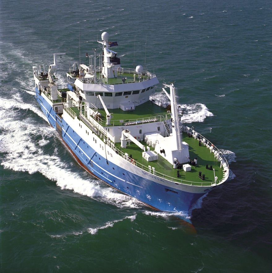
MRV Scotia Programme
Survey: 0519S
Duration: 16-24 April 2019
Gear:
- Sea-Bird Conductivity/Temperature/Depth (CTD) unit;
- Autonomous Underwater Vehicle (AUV);
- PIES mooring;
- Acoustic Doppler Current Profilers (ADCPs);
- Current meter instrumentation;
- Water filtering equipment;
- Mooring equipment; and
- Chemistry sampling equipment.
Procedure
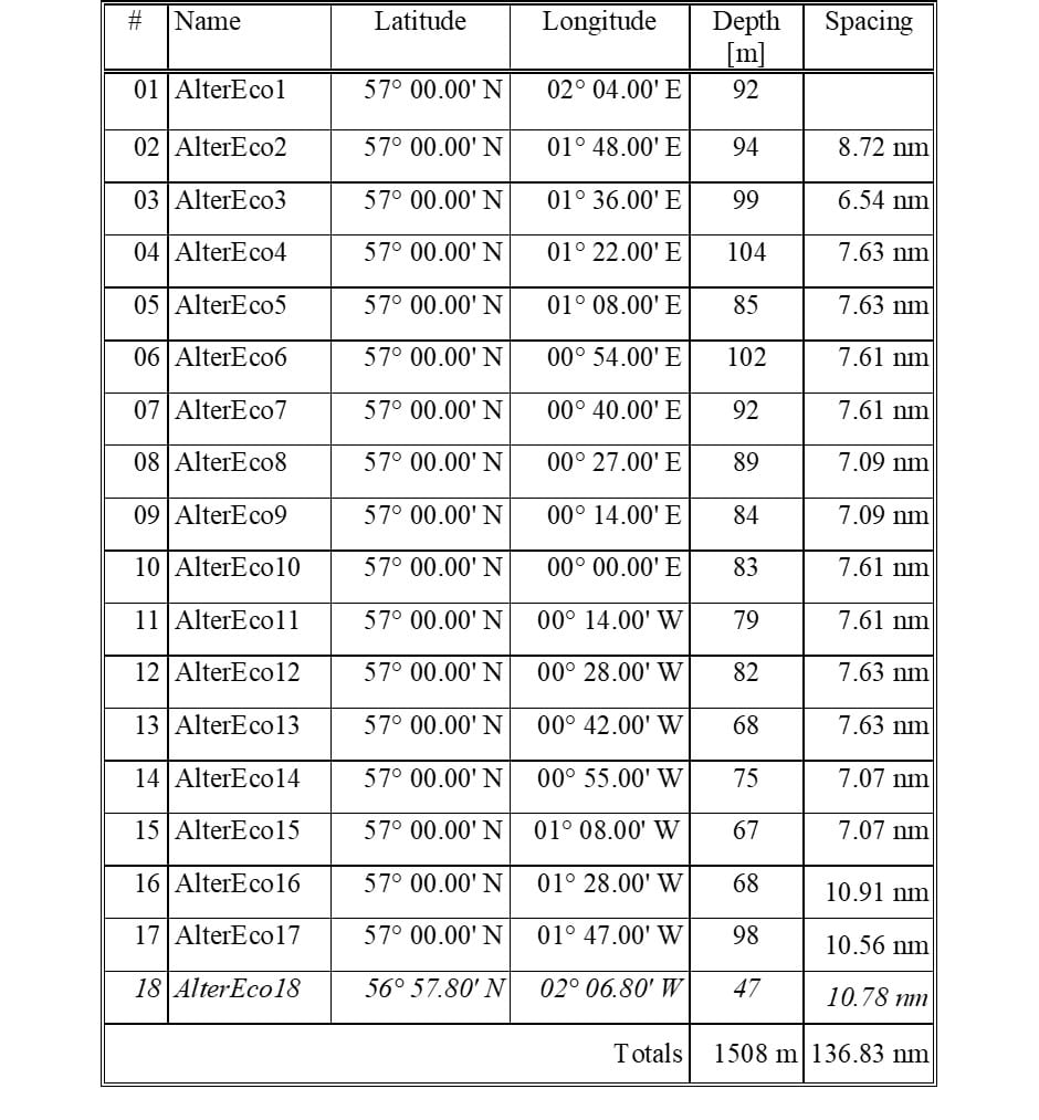
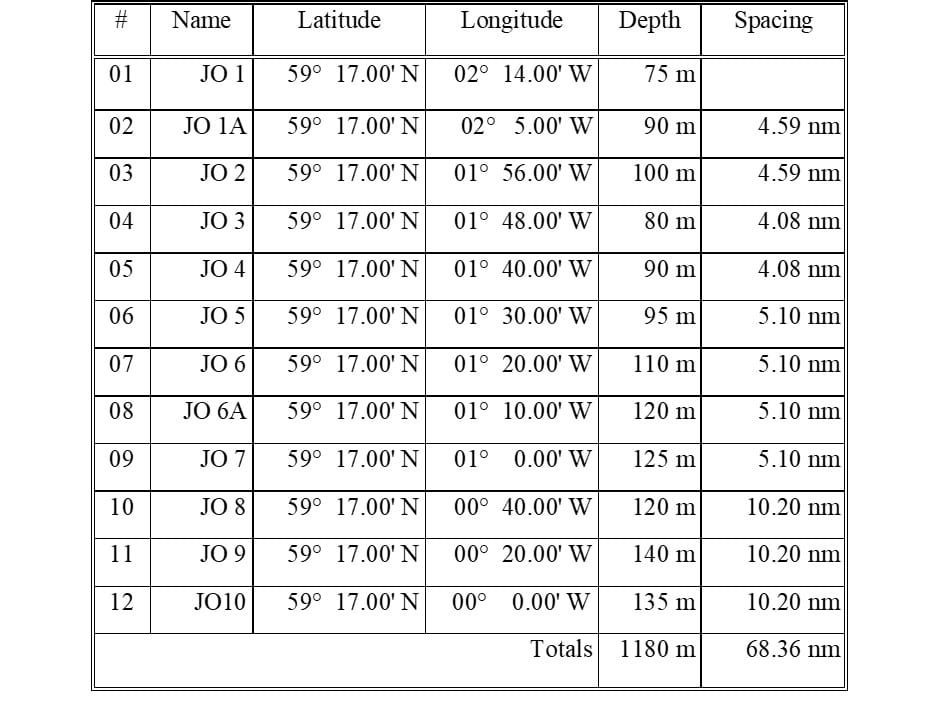
On sailing from Aberdeen MRV Scotia will make passage to the start (western end) of the AlterEco monitoring section to carry out sampling with the CTD unit and carousel water sampler along the section. On completion of that section, Scotia will head to the mooring position in the Moray Firth to recover an ADCP mooring deployed in an AL200 trawl-proof frame, download the data and proceed to the JONSIS section to carry out sampling with the CTD unit and carousel water sampler. Scotia will then recover an ADCP mooring on the Fair Isle – Munken (FIM) section (NWSE). Data will be downloaded and the mooring will then be re-deployed there.
Scotia will then make her way to the eastern start of the Nolso – Flugga (NOL) section and, depending on timings, either recover one ADCP mooring (NWEZ) along the way or start collecting long term monitoring samples and taking CTD profiles from the start of the section. At relevant locations along NOL mooring deployments will be carried out, with calibration CTD dips for instruments recovered from some of the moorings; overall, two ADCP moorings, one PIES mooring and a buoyancy glider (AUV) will be deployed.
After the NOL section, Scotia will head to the western (Faroe) side of the FIM section to carry out standard CTD and water sampling along that line. Once that work is completed and if time allows, Scotia will attempt to re-deploy in a different location in the Moray Firth the mooring recovered there at the start of the survey and then carry out additional work (listed among the survey objectives) along the JONSIS line, in the Moray Firth and/or Aberdeen Bay, prior to her return to Aberdeen. If the weather requires sheltering in Shetland and any point during the survey, we will aim to collect additional CTD and VMADCP data in suitable locations (e.g. Yell Sound).
Objectives:
- Perform hydrographic sampling along the AlterEco monitoring section in the northern North Sea.
- Recover and download an ADCP mooring deployed in a trawl-proof frame in the north of the Moray Firth.
- Perform hydrographic sampling along the JONSIS long term monitoring section in the northern North Sea.
- Recover, download and re-deploy one ADCP mooring at a position on Fair Isle – Munken (FIM/NWS) section.
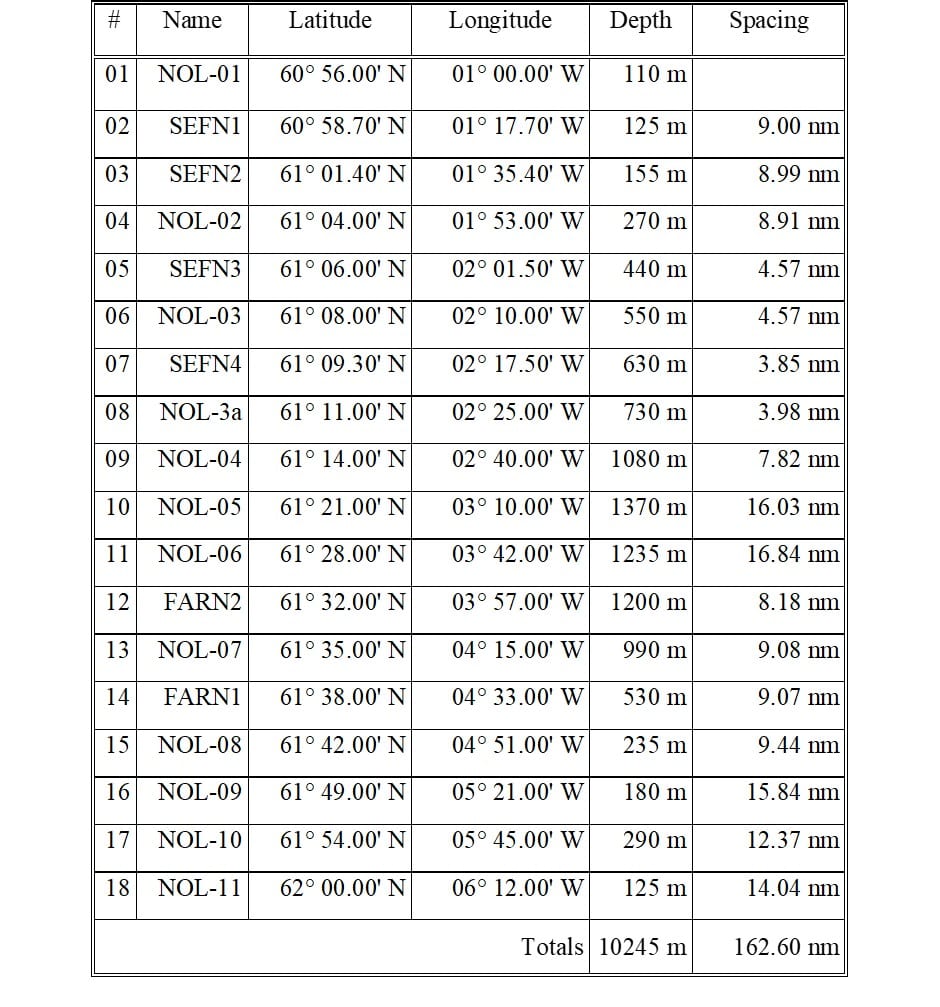
- Perform hydrographic sampling along the long term monitoring Faroe-Shetland Channel Nolso – Flugga (NOL/NWE) section.
- Recover, download and re-deploy one ADCP mooring at a position on Faroe-Shetland Channel Nolso – Flugga section.
- Deploy a second ADCP mooring off the shelf at a position on Faroe-Shetland Channel Nolso – Flugga section, deploy a PIES mooring nearby and deploy a buoyancy glider (AUV) in the same area.
- Take water samples for long term storage on Fair Isle – Munken and/or Nolso – Flugga section stations.
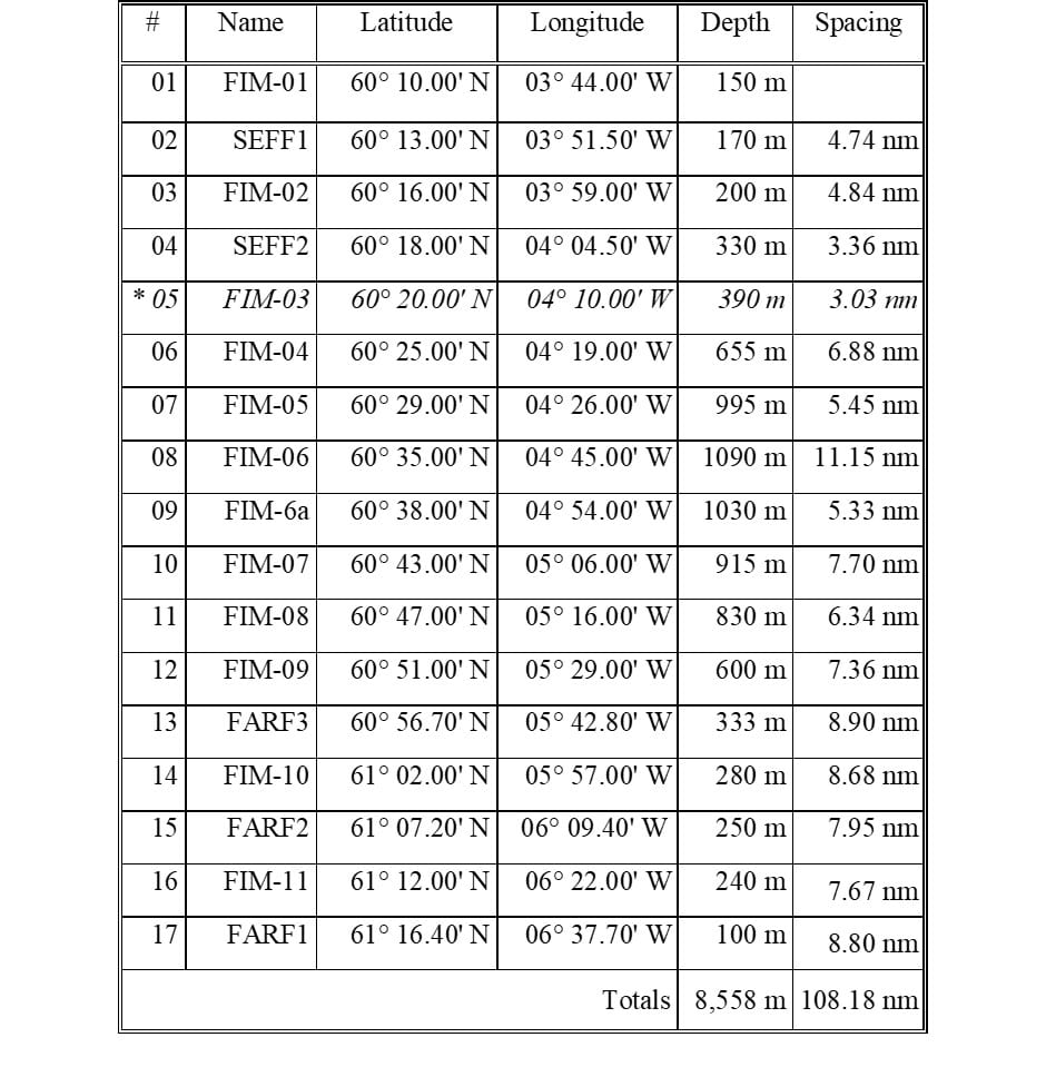
- Perform hydrographic sampling along the long term monitoring Faroe-Shetland Channel Fair Isle – Munken (FIM/NWS) section.
- Run the thermosalinograph throughout the survey and VMADCP along hydrographic sections.
- Perform hydrographic sampling in the vicinity of a number of ADCP moorings in order to calibrate moored equipment: CTD dips at selected locations with equipment (SB56 NanoCAT and/or SB57 MicroCAT) attached to carousel.
- If sheltering in a suitable location around Shetland due to bad weather, conduct VMADCP/CTD work (e.g. Yell Sound).
- Re-deploy the ADCP mooring in a trawl-proof frame recovered earlier in the Moray Firth in a nearby location in that area.
- If weather/time permits, perform fine scale VMADCP/CTD survey work on the JONSIS line (around 59° 16.96′ N, 001° 15.26′ W).
- If weather/time permits, perform VMADCP/CTD survey work in the Moray Firth and/or Aberdeen Bay.
Mooring Positions (Recovery)
Moray Firth – 58° 18.47’ N 002° 58.54’ W
NWSE – 60° 16.30′ N 004° 20.77′ W
NWEZ – 61° 09.34′ N 002° 17.35′ W
NWEA – 61° 38.01′ N 004° 32.60′ W (lost)
Mooring Positions (Deployment)
Moray Firth – 58° 16.80’ N 002° 56.70’ W (*)
NWSE – 60° 16.29′ N 004° 20.78′ W on FIM
NWEZ – 61° 09.30′ N 002° 17.52′ W on NOL
NWEX – 61° 11.00′ N 002° 25.00′ W on NOL
PIES – 61° 11.00′ N 002° 25.00′ W on NOL (in practice, small offset from NWEX)
(*) final position may change by a little
Scientific Procedures
It is expected that deployments of hydrographic equipment will be carried out with the CTD crane whilst the vessel is on station. The plankton crane will be used for the deployment of ADCP moorings in trawl-proof frame (AL200) and the PIES mooring. Single-string ADCP mooring deployments will be done from the trawl deck. The AUV will be lowered into the water from the hanger deck.
Below: Position of hydrographic sections (small diamonds) and proposed position of new mooring deployments (small flags with name labels).
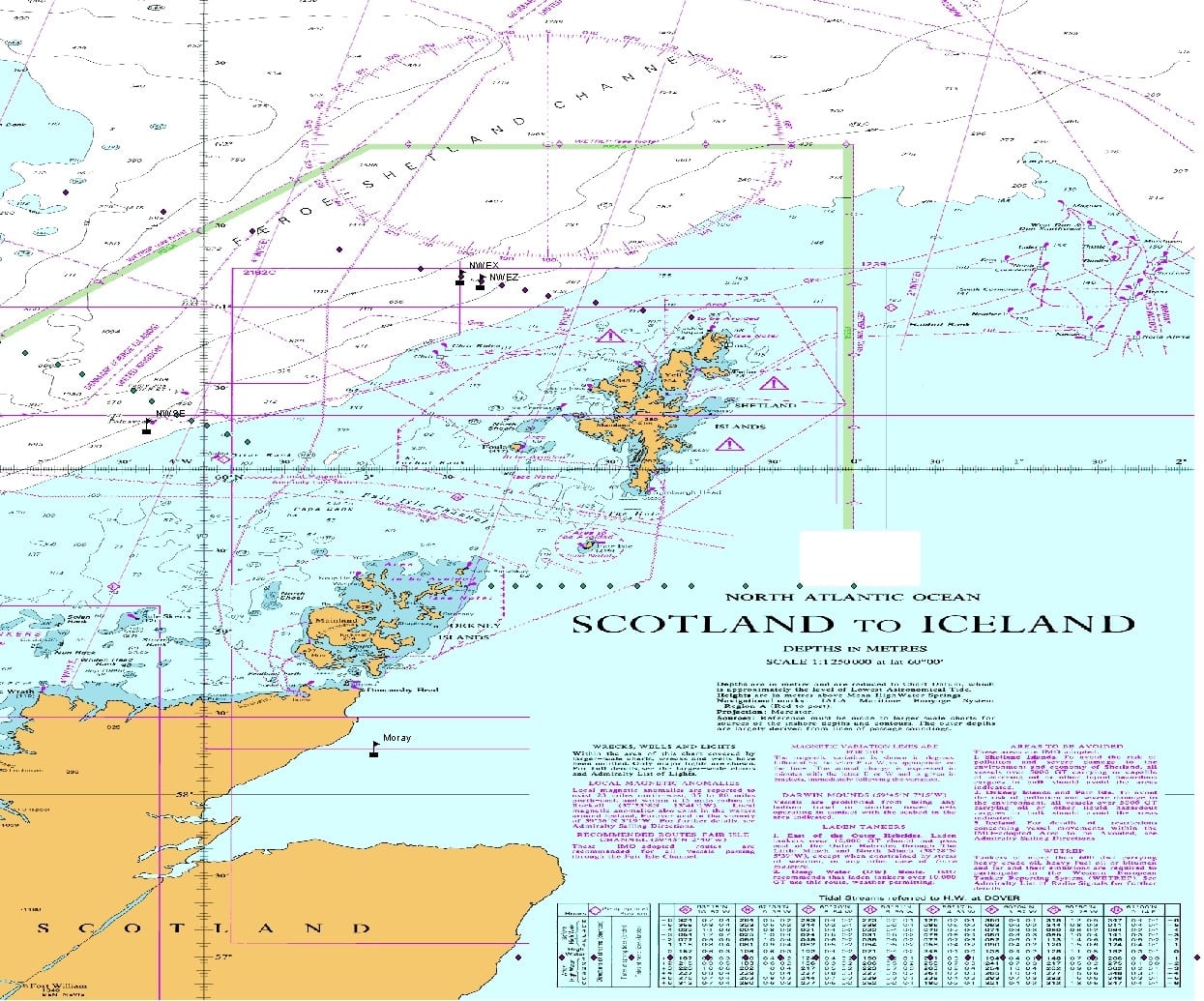
ALTERECO Line
JONSIS Line
Fair Isle – Munken (Amended for presence of Foinaven oil platform*)
Nolso-Flugga
Further Information:
Tags: Aberdeen Bay, hydrographic sampling, hydrography, moorings, Moray Firth, MRV Scotia, oceanography, research, sampling, science, Scotia, Survey

Leave a comment